Falkensteiner Höhle
Falkenstein Cave - Elsachbröller
Useful Information
| Location: |
B28 from Ulm, Blaubeuren, to Metzingen, in Bad Urach turn right towards Grabenstetten, after 3 km parking lot, right hand side, 15 min walk.
(48.5140433, 9.4527559) |
| Open: |
Entrance area no restrictions. Cave accessible only with permit by the municipality. During Summer Sundays, information booth by members of the ArGe Höhle und Karst Grabenstetten at the cave entrance. [2023] |
| Fee: |
free. [2023] |
| Classification: |
 Karst Cave
River Cave Karst Cave
River Cave
 Karst Spring
Malm (Upper Jurassic) limestones. Karst Spring
Malm (Upper Jurassic) limestones.
|
| Light: | bring torch |
| Dimension: | L=4,259 m. |
| Guided tours: | L=50 m, 400 m with good equipment. |
| Photography: | allowed |
| Accessibility: | no |
| Bibliography: |
Helmut Frank (1973):
Falkensteiner Höhle,
Laichinger Höhlenfreund 16/17.
K.-H. Zimmermann (1978): Die Falkensteiner Höhle, Besucherinformation, ArGe Höhle und Karst Grabenstetten, 2. Auflage. (2017): Besucherinfo Falkensteiner Höhle, Grabenstetten, 2017. online |
| Address: |
Arbeitsgemeinschaft Höhle und Karst Grabenstetten e.V., Tewje Mehner (1. Vorsitzender), Schloßgasse 1, 72660 Beuren-Balzholz.
E-mail: Gemeindeverwaltung Grabenstetten, Böhringer Straße 10, 72582 Grabenstetten, Tel: +49-7382-941504-0. E-mail: |
| As far as we know this information was accurate when it was published (see years in brackets), but may have changed since then. Please check rates and details directly with the companies in question if you need more recent info. |
|
History
| 1770-1830 | gold digger searched futilely for gold. |
| 1871 | first exploration and survey by Kolb to the 1st siphon. |
| 1953 | ArGe Höhlenforschung Reutlingen explores the cave to the Fuchsloch (Fox Hole) at 1,200 m. |
| 1959 | explortion to the EISELE-Versturz at 2,700 m. |
| 1964 | a flood traps four students for 66 hours in the cave. |
| 1974 | survey and map by the HHVL. |
| 1975 | in the international year of cave protection, the Arge Grabenstetten starte to make guided visits. |
| 1978 | new end is at 3,300 m. |
| 1979 | another 500 m dived by Hasenmmeyer. |
| 1980 | Hasenmayer dives to 5,000 m and the 26th siphon. |
| 2017 | new passage near the Fuchsbau discovered. |
| APR-2018 | Gemeinde Grabenstetten issues a police regulation for entering the Falkenstein Cave. |
Description

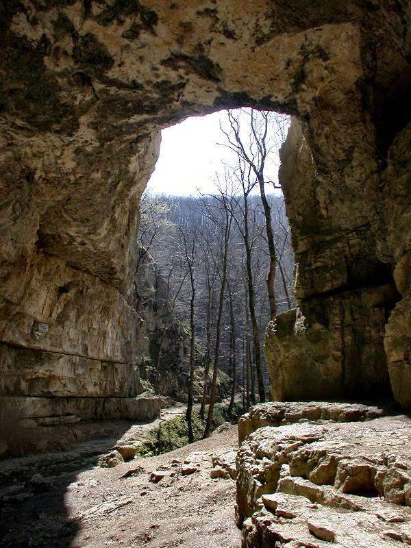

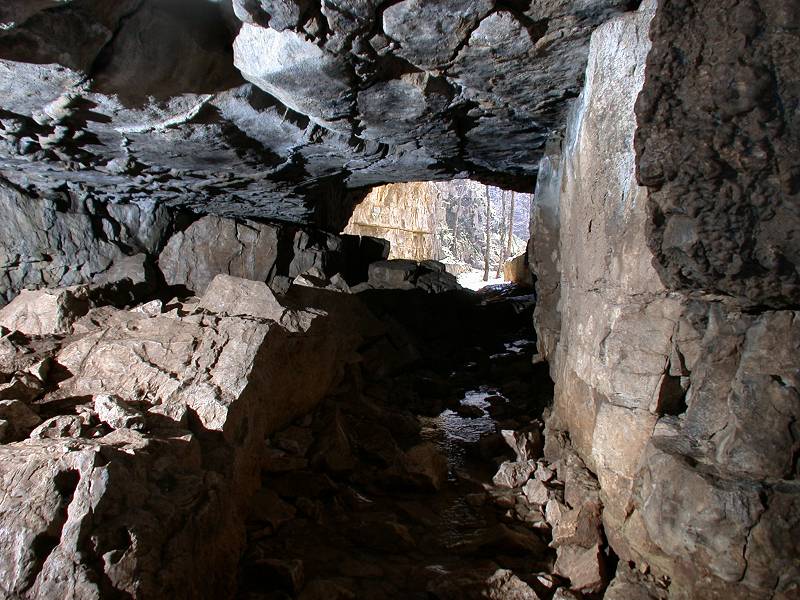
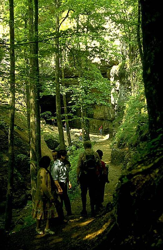
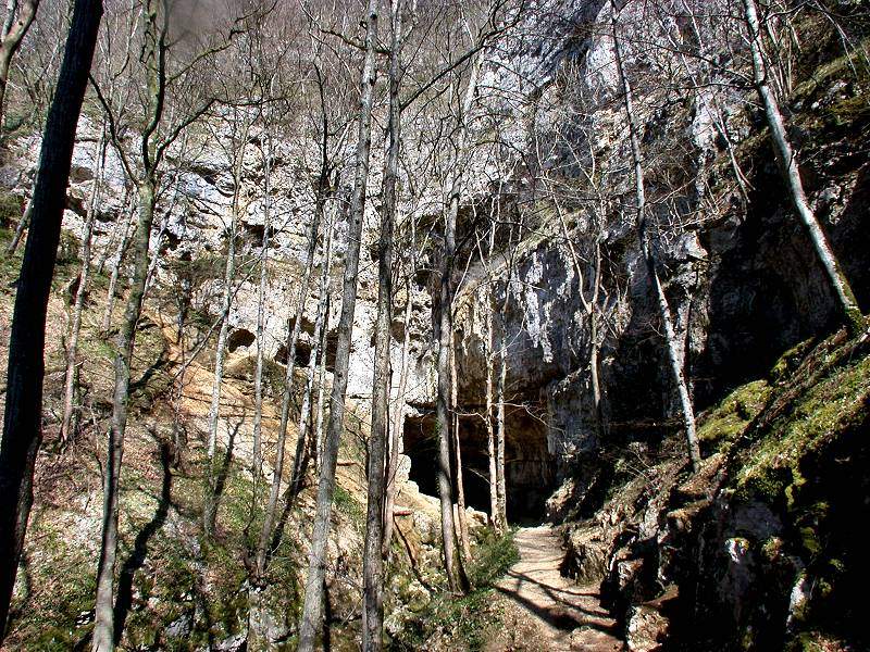
The Falkensteiner Höhle (Falkenstein Cave) is certainly the most famous of the undeveloped caves in the Swabian Alb. This is partly due to the magnificent and romantic entrance portal, but also due to the special thrill of an active river cave. However, four students discovered quite impressively in 1964 that this is not harmless at all. While they were in the cave, heavy rain caused the water level in the cave to rise so high within a few hours that their way back was cut off. Since then the made headlines with frequent rescue operations, and the cave rescue actually has at least one rescue every year. We would therefore like to warn you once again:
Even the route to the first siphon has its pitfalls, but an ascent beyond the first siphon should only be carried out well equipped and under the guidance of an experienced speleologist. In addition, since 2018, visiting the cave is not allowed without permission from the municipality of Grabenstetten. This was necessary to curb the large number of accidents.
Even those unfamiliar with the cave can enter the first 400 metres of the Falki up to the first sipon if they follow a few important rules and are adequately equipped. These include rubber boots, a helmet, several light sources, neoprene and very close observation of the weather. However, this descent is not particularly pleasant due to the cold water that reaches up to your chest.
Since the International Year of Cave Conservation in 1975, the
 Arbeitsgemeinschaft Höhle und Karst Grabenstetten
(Grabenstetten Cave and Karst Working Group) has been providing caving services at Falkenstein Cave at weekends from May to September.
Visitors are informed in detail about all aspects of the cave, local geology, and accessibility.
The cave explorers point out any deficiencies in the equipment to visitors and give tips for safe exploration.
However, guided tours are not possible due to the dangerous nature of the cave and the associated legal and insurance problems.
Further information is available directly from their website.
Arbeitsgemeinschaft Höhle und Karst Grabenstetten
(Grabenstetten Cave and Karst Working Group) has been providing caving services at Falkenstein Cave at weekends from May to September.
Visitors are informed in detail about all aspects of the cave, local geology, and accessibility.
The cave explorers point out any deficiencies in the equipment to visitors and give tips for safe exploration.
However, guided tours are not possible due to the dangerous nature of the cave and the associated legal and insurance problems.
Further information is available directly from their website.
We have listed the Falkenstein Cave not because of the river passages. The cave has an impressive portal and a cave stream that leaves it. The first 50 m can be entered on dry foot and are safe, but still give an impression of the character of the cave. The surrounding area is very scenic, and the cave is an ideal stopover or starting point for a hike. It is always a worthwhile destination, especially with children.
The Falkenstein Cave has also found its way into literature.
It is described in Christian David Friedrich Weinland’s Book
 Rulaman
(1876) as Huhka or Eagle Owl Cave.
The name was derived from the eagle owls that nest in the rock above the cave entrance.
Rulaman
(1876) as Huhka or Eagle Owl Cave.
The name was derived from the eagle owls that nest in the rock above the cave entrance.
Opposite the Falkenstein Cave is the Elsachbröller cave. During heavy rainfall and when the snow melts, it pours a large amount of water. The resulting roaring sound is probably responsible for the name, "brüllen" is the German word for "roaring". It is assumed that the Elsachbröller is the continuation of the Falkenstein Cave. The cave was split into two parts of the valley, which cut into the plateau due to retrograde erosion. The course of the valley between the two caves most likely follows the former course of the cave. The Elsachbröller can only be entered by experienced cavers. Entering the cave is even more dangerous than Falkenstein Cave.
|
|
| Falkensteiner Höhle Gallery |
- See also
 Search DuckDuckGo for "Falkensteiner Höhle"
 Google Earth Placemark
 OpenStreetMap
 Falkensteiner Höhle
  - Wikipedia (visited: 05-OCT-2014)
- Falkensteiner Höhle « Arbeitsgemeinschaft Höhle und Karst Grabenstetten e. V. (visited: 04-NOV-2023)
- Falkensteiner Höhle (visited: 04-NOV-2023)
- Falkensteiner Höhle (visited: 04-NOV-2023)
- Falkensteiner Höhle (visited: 04-NOV-2023)
- Falkensteiner Höhle | Hohlraumbeschreibung (visited: 04-NOV-2023)
 Index
Index Topics
 Hierarchical
 Countries
 Maps
Maps