Kaymaklı Yeraltı Şehri
Kaymakli Underground City - Ανακού - Enegup
Useful Information
| Location: |
Camii Kebir Mah. Eşref Ayhan Cad. No:46 Kaymaklı/Nevşehi̇r.
In the centre of the village of Kaymaklı. On the Nevsehir-Derinkuyu road D-765, 18 km south of Nevsehir. (38.465556, 34.750556) |
| Open: |
APR to OCT Tue-Sun 8-19, last entry 18:15. NOV to MAR Tue-Sun 8-17, last entry 16:15. [2023] |
| Fee: |
Adults TRL 300. [2023] |
| Classification: |
 Underground City Underground City
|
| Light: |
 Electric Light Electric Light
|
| Dimension: | VR=20 m. |
| Guided tours: | self guided |
| Photography: | allowed |
| Accessibility: | no |
| Bibliography: | |
| Address: | Kaymaklı Yeraltı Şehri, Cami Kebir Mahallesi yeraltı şehri Belediye Caddesi, 50760 Nevşehir, Tel: +90-384-213-14-47, Cell: +90-532-788-76-25. |
| As far as we know this information was accurate when it was published (see years in brackets), but may have changed since then. Please check rates and details directly with the companies in question if you need more recent info. |
|
History
| 2000 B.C. | first three floors carved out by Hittites. |
| 14th century | when Turkey was under siege by the Byzantines, the citizens moved into the caves to hide from the Arabs. |
| 1923 | city abandoned after a population exchange between Turkey and Greece. |
| 1964 | opened to the public. |
| 1985 | inscribed on the UNESCO World Heritage List. |
Description
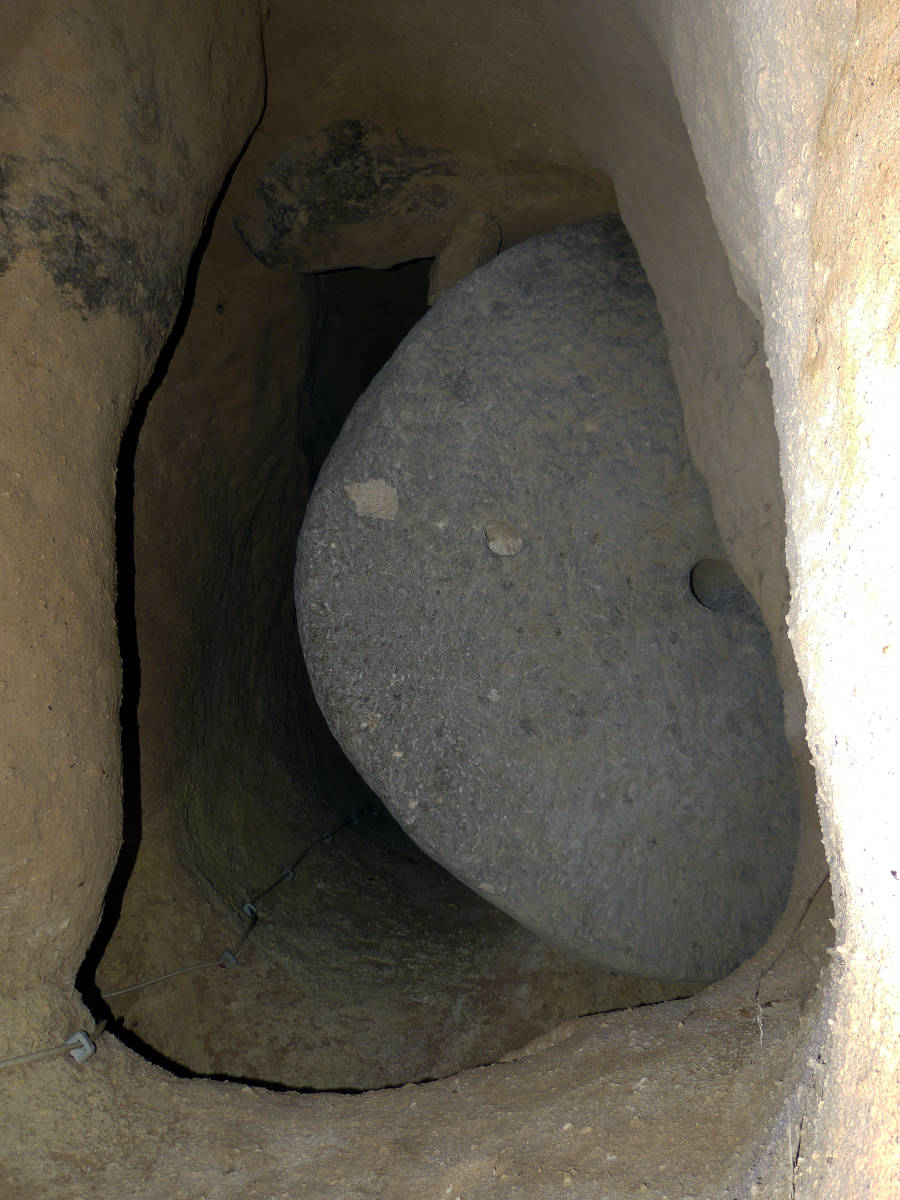

Kaymaklı Yeraltı Şehri (Kaymakli Underground City) is a complex underground city with eight levels, big enough to house 5,000 people. There are different rooms for all purposes like grain storage, stables for the animals, wine cellars, and all other needs of rural life. Even the wineries and floor mills were underground. There are also underground chapels, places for worship and cemetries. The city is protected by a system of strong doors, some were obviously wooden, but there are several millstone-like rock which were rolled in front of the door. Dead-end corridors and labyrinths were used to trap the intruders and kill them. And if anything else failed, there are secret escape routes.
The age of the underground cities is very hard to determine. There is no physical method to determine when rock was cut. Age determination needs content, especially wood, which tells a sort of minimal age. The first three floors of this structure were probably carved out by Hittites. This is a conclusion depending on the architecture and other archaeological results. This would mean an age of about 4,000 years. The area was then settled by Assyrians, Lycians, Persians, and Kimmerians. It is not clear if the city was used during this time. But it was again used during the early time of the Roman occupation, which started about one century BC. Until 376 A.D. the Christian Religion was prosecuted, and the early Christians used this city during this time. During this time, the city was enlarged and modified.
Although the city has eight levels, only four are open to the public. The top level was used until recent time. The owners of the surrounding houses created entrances and used it as cellars. Originally, this level was used mainly as stables for domestic animals. The second level shows a christian church and a cemetery, some living rooms, and a huge rock used to block the entrance. The third floor is for storage of grain, floor and wine, and contains the winery and the floor mill. The forth floor has a communal kitchen with several food storage areas and ovens. A huge block of andesite was used to block the entrance. During peaceful periods it was used as a foundation for burning mortar or melting copper. This hard and heavy rock is also a volcanic rock, but from other layers than the soft tufa, and it was mined somewhere else and moved to the city.
- See also
 Subterranean World Heritage List
 Search DuckDuckGo for "Kaymaklı Underground City"
 Google Earth Placemark
 OpenStreetMap
 Kaymaklı Underground City - Wikipedia
 Kaymakli Underground City (visited: 21-OCT-2020)
- Göreme National Park and the Rock Sites of Cappadocia - UNESCO World Heritage List (visited: 15-APR-2023)
 Index
Index Topics
 Hierarchical
 Countries
 Maps
Maps