Source du Lison
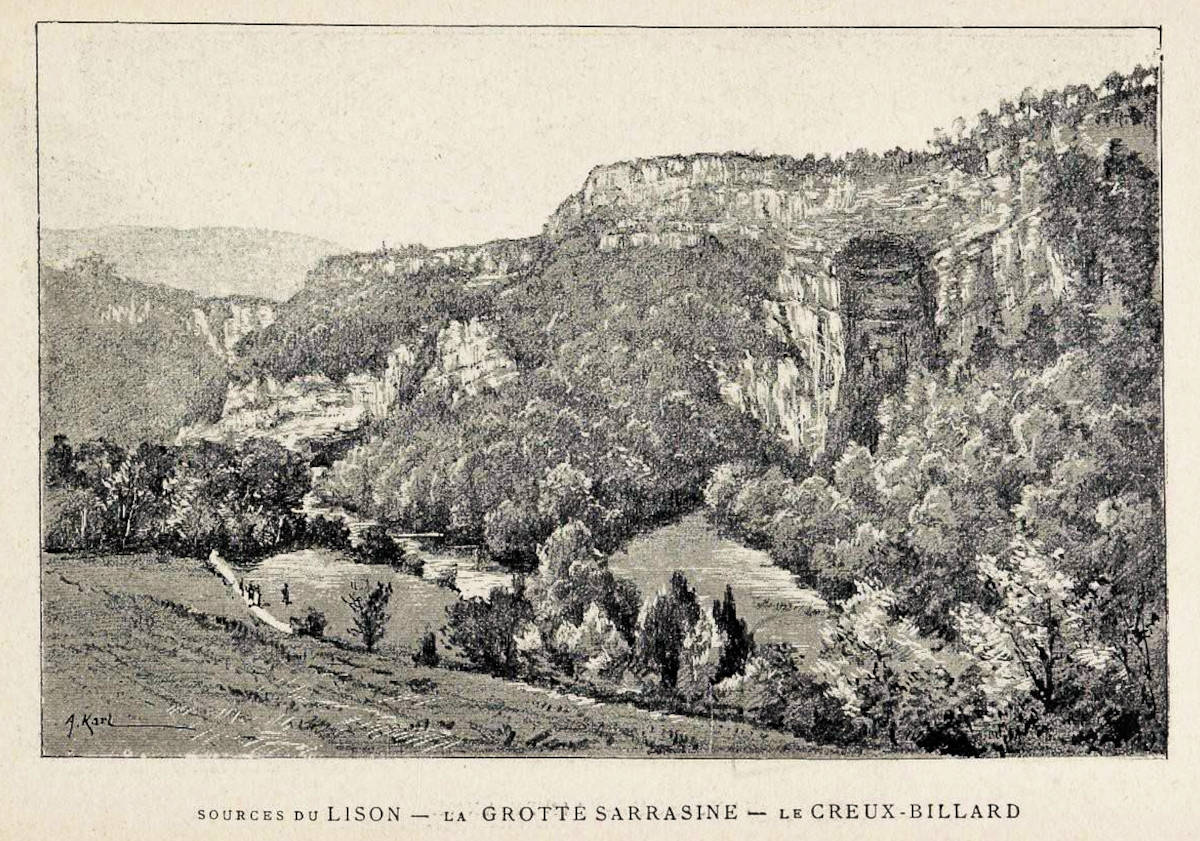
Creux Billard - Grotte Sarrazine
Useful Information
| Location: |
25330 Nans-sous-Sainte-Anne.
Nans-sous-Sainte-Anne, 44 km south of Besançon and 13 km east of Salins-les-Bains. From the parking lot 200 m to the Source du Lison, 150 m further to Creux Billard, 480 m to Grotte Sarrazine. (46.9652311, 6.0111011) |
| Open: |
No restrictions. [2022] |
| Fee: |
free. [2022] |
| Classification: |
 Karst Spring Karst Spring
|
| Light: | n/a |
| Dimension: |
Source du Lison:
A=382 m asl, Yavg=5.35 m³/s, Ymax=100 m³/s. Creux Billard: Ø=60 m, VR=90 m. Grotte Sarrazine: H=100 m, W=30 m, D=30 m, A=399 m asl. V=150.000/a [2019] |
| Guided tours: | self guided |
| Photography: | allowed |
| Accessibility: | no |
| Bibliography: | |
| Address: | Source du Lison, 25330 Nans-sous-Sainte-Anne, Tel: +33-3816-22150. |
| As far as we know this information was accurate when it was published (see years in brackets), but may have changed since then. Please check rates and details directly with the companies in question if you need more recent info. |
|
History
| 12th century | first mills installed along the river. |
| 1889 | connection between Creux Billard and the Source du Lison proven by the dead body of a drowned girl. |
| 1899 | owner of the mill wanted to tap the water of the spring and thus stop the flow of the waterfall. |
| 21-APR-1906 | trial on the source of the Lison decided. |
Description
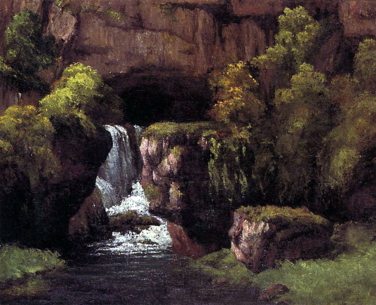
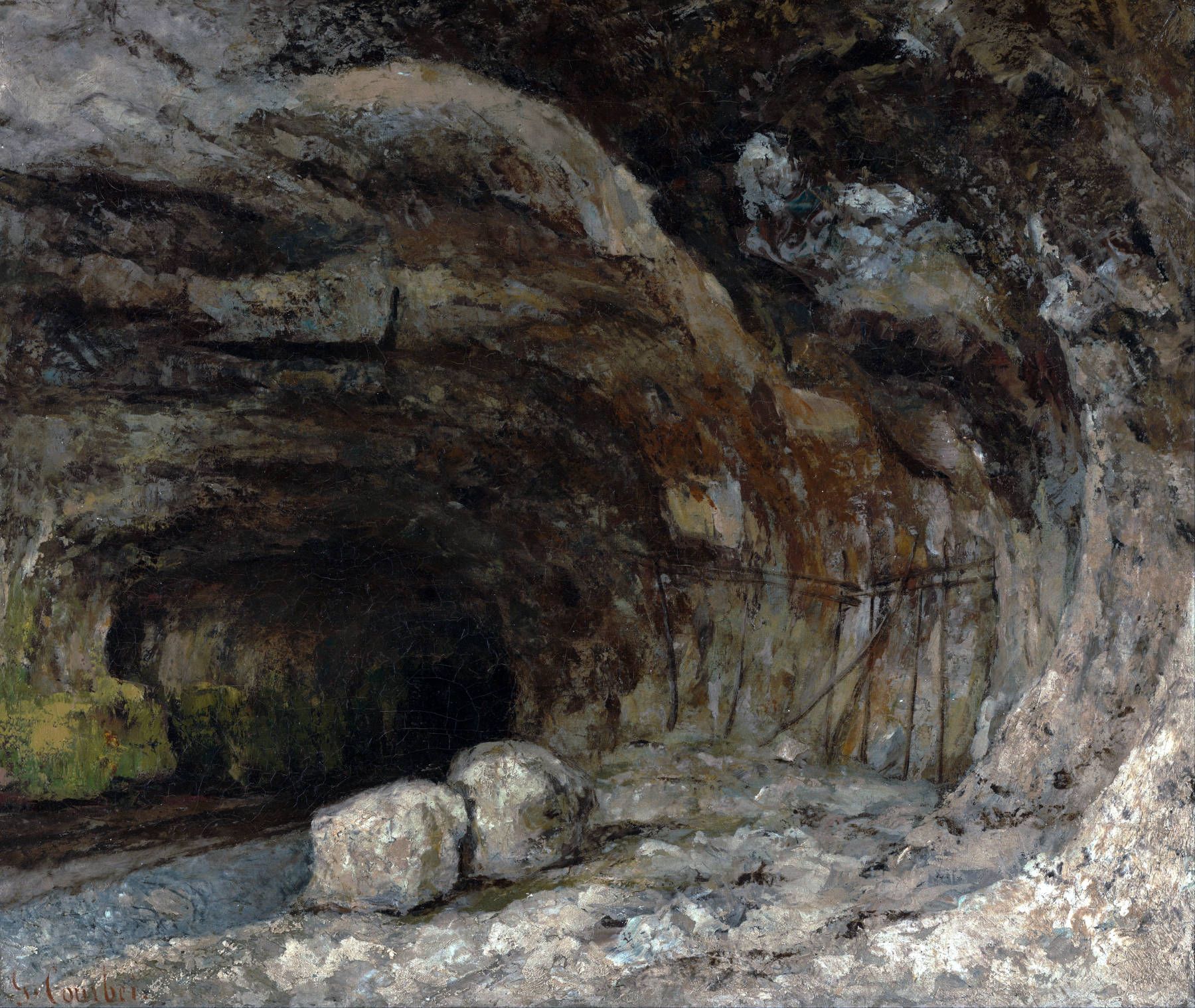
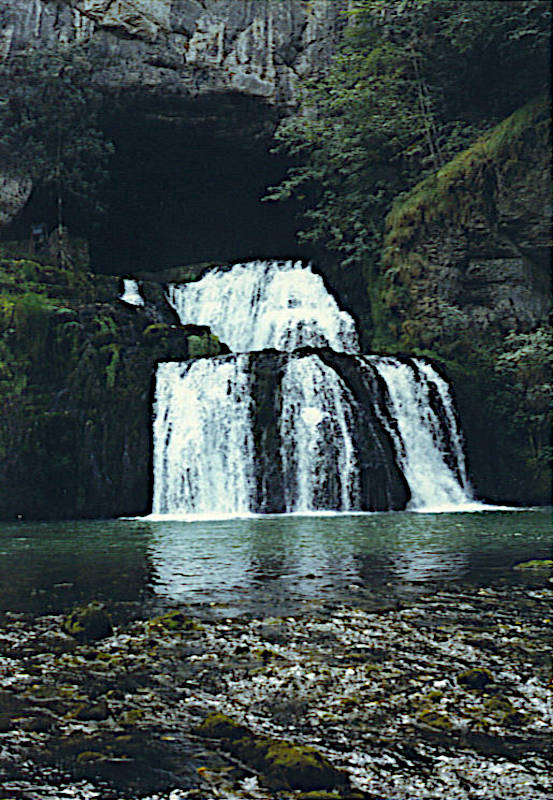
The Source du Lison (Spring of the Lison) is an impressive karst spring, the resurgence of the Lison river. The river flows out of the portal of a water-filled cave at the foot of a limestone cliff, the amount of water is huge and may become enormous during spring and after heavy rain. The cave is partly accessible, but not from the spring. The remains of a water mill with a channel and the foundation for the long gone water wheel can be seen. It used the power of the water flowing down the waterfalls in front of the cave entrance. A level trail along the channeled river ends at those ruins, and a much smaller trails with stairs along the ruins allows to enter the cave portal. It goes up a stone staircase and then on a ledge along the left wall of the entrance. This path seems to be mostly artificial, probably a remains of the water mill. However, after only 40 m the ceiling descends until it is below water level, in other words: any advance requires cave diving. Despite strongly changing yield over the year, the source of the Lison never dried up completely. Once this was quite important for people living in the area, who depended on the spring for drinking water.
The whole site is the end (or the beginning) of the valley of the Lison river. It ends quite spectacularly with an amphitheatre of vertical limestone cliffs. The nearby village Nans-sous-Sainte-Anne is located in the valley at 367 m asl, while the surrounding limestone hills reach 700 m asl. In the middle of this amphitheatre is a huge parking lot with kiosk, the site is quite popular in summer and may be crowded. Most visitors just walk the 200 m along the artificial canal to the main source and back, and this part is actually wheelchair accessible and suitable for strollers. Unfortunately it is also the most uninteresting part of the site. You should definitely visit both the Grotte Sarrazine and the Creux Billard. And by the way, the best time of the year to visit the spring is late winter and early spring. Not because of the visitor crowds, because at this time snow melt makes the yield 10 to 20 times higher than average, which is quite spectacular.
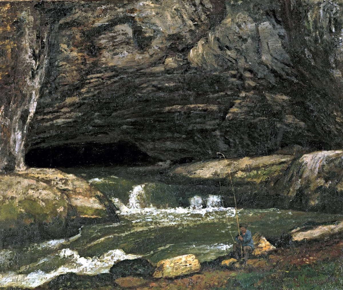
The painter Gustave Courbet, full name Jean Désiré Gustave Courbet, (*1819-✝1877) originated from nearby Ornans, and he painted both the landscape of the Jura and naked women. We are not sure for what he is more famous. However, we have several of his oil paintings on this page, which are now in the public domain. They are extremely realistic and give a good impression of the site.
The water mill at the entrance of the spring used the fact that the spring is about 10 m higher than the valley floor, and the water flows down a two-step waterfall, right in front of the portal. The mill collected the water at the spring and used this height difference. In 1899, the owner of the mill applied to tap the water of the Lison completely and thus stop the flow of the waterfall. Even then, when people were still believing in technology, they realized the resulting destruction of a nature monument. The residents of Nans-sous-Sainte-Anne, the nearest village, resisted and after two lawsuits eventually won their case. The resistance was organized by their Député du Doubs (MP), Charles Beauquier, and he continued the fight until the first environmental protection law of France was passed. It was called the Beauquier Act and the source of the Lison became the second listed site. Its actual name was - quite dull - loi du 21 avril 1906, after the date of the trial between the owner of the mill and the nature protectionists. It organized the protection of natural sites and monuments of an artistic nature. In 1913, it was extended by a law on the protection of historic monuments. Finally, in 1930 both became a part of the law for the protection of natural monuments and sites of an artistic, historical, scientific, legendary or picturesque character. It seems the mill was not able to survive after that, and was demolished soon after. Probably, if the law for the protection of historic monuments would have existed already, it might have been declared a Historical Monument instead.
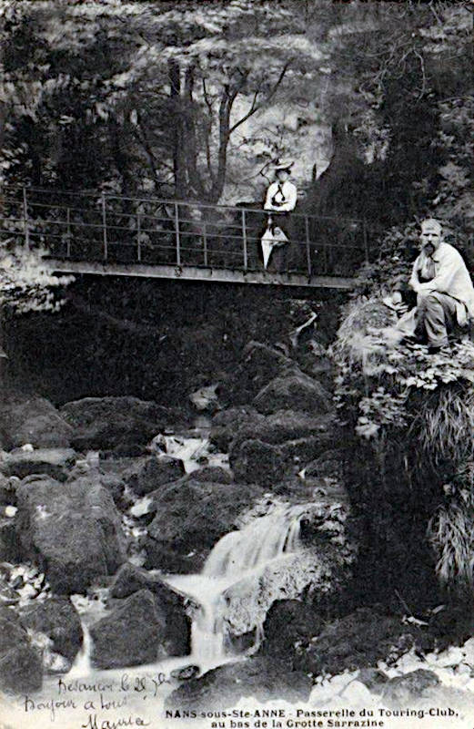
Right behind the entrance portal the cave passage goes down and forms a deep siphon. The trail on the left wall of the portal ends here, only cave divers can enter the siphon. Fortunately it is not necessary to bring diving gear, there is a trail uphill which leads to a huge collapse doline or sinkhole named Creux Billard. Only 50 m behind the spring the roof of the cave is collapsed and forms this huge almost circular doline with vertical walls. At the floor of the doline flows the water which is swallowed underwater by the cave and re-emerges soon at the spring. The connection was first confirmed by a freak accident in 1889, when a young girl fell into the lake and drowned. Her body vanished underwater, but was found 8 days later downstream from the spring.
On the opposite side of the doline the water emerges from the cave system, similar to the first spring. But during high yield a second cave level higher up is reactivated, the passage ends in the middle of the vertical cliff about 20 m above the floor. Left of this cave entrance is a waterfall, which flows only after heavy rains. It is the surface drainage of the plateau behind, which is reactivated only with huge amounts of water, if the cracks are too small to swallow all. It is called Château-Renaud river, and is dry most of the year. The outlook is located high above the river at the rim of the doline, but at a place where there is a sort of gap. It is only about 30 m above the floor, right opposite the cave spring and the waterfall. Its definitely worth a visit when both, cave and Château-Renaud river are flowing, though this is quite rare.
Nearby is another spring which is called Grotte Sarrazine (Saracen’s cave), it forms a 200 m long left tributary of the Lison river. To reach it cross the Lison on the bridge at the parking lot and follow the trail uphill along the tributary. Its yield is smaller than the main spring, and sometimes it falls dry, and it is possible to enter the cave behind to some extent. After an elliptical, tube-like passage a siphon with a massive flowstone formation follows. The passage formed along an almost horizontal bedding plane, and is wid but rather low. The spring itself is less spectacular, but the entrance portal is quite impressive. It forms a huge abri or shelter, where the weathering of the rock around the spring created an overhang. Most likely a result of frost weathering, which is intensified by the humidity of the spring. It is like a huge half dome, 100 m high and 30 m wide, which can be seen from far away.
 Search DuckDuckGo for "Source du Lison"
 Google Earth Placemark
 Lison (rivière)
  - Wikipedia (visited: 20-NOV-2022)
 Balade à Nans sous Ste Anne, Source du Lison
  Index
Index Topics
 Hierarchical
 Countries
 Maps
Maps