Tiefer Molchner Stollen
Zum tiefen Molchner Stolln
Useful Information
| Location: | A4 Eisenach-Dresden exit Chemnitz-Nord, or A72 Hof Chemnitz exit Chemnitz-Süd. B174 towards Zschopau-Marienberg. In Marienberg B171 towards Olbernhau. 5 km after Marienberg trun right on road to Pobershau. |
| Open: |
All year daily 9-16, tours hourly on the full hour. Technikführung: MAY to OCT after appointment. Sonderführungen: after appointment. [2011] |
| Fee: |
Adults EUR 4,50, Children (4-18) EUR 3, Children (0-3) not allowed. Groups (15+): Adults EUR 4, Children (4-18) EUR 2,50. Technikführung: Adults EUR 6, Children (4-18) EUR 4,50. Sonderführungen: Adults EUR 15. [2011] |
| Classification: |
 Silver Mine Silver Mine
|
| Light: |
 Electric Light Electric Light
|
| Dimension: | |
| Guided tours: |
D=45 min, two persons minimum.
Sonderführungen: D=2,5 h. |
| Photography: | |
| Accessibility: | |
| Bibliography: | |
| Address: |
Schaubergwerk Molchner Stolln, Amtsseite Dorfstr. 67, 09496 Pobershau, Tel: +49-3735-62522, Cell: +49-173-9302081.
E-mail: |
| As far as we know this information was accurate when it was published (see years in brackets), but may have changed since then. Please check rates and details directly with the companies in question if you need more recent info. |
|
History
| 1484 | first written mention of mining in the area. |
| 1529 | Drey Molchen Fundgrube first mentioned. |
| 1540 | highest production of the mine. |
| 1866 | mine closed. |
| 1934 | developed as a show mine. |
| 1935 | show mine opened to the public. |
| 1936-1938 | geologic exploration. |
| 1947-1954 | mining by the SDAG Wismut. |
| 1959 | reopening of the show mine. |
Geology
In the Marienberg county the bedrock consists of varios kinds of gneiss. There is paragneiss which is the metamorphization of sedimentary rock and is locally called Graugneis (grey gneiss). And there is orthogneiss derived from an igneous rock, which is called Rotgneis (red gneiss). Those highly metamorphic rocks are ofprecambrian age. The rock is full of lamprophyre dykes with are between 20 cm and 6 m wide and run northwest to southeast. They contan high amounts of limestone and calcite minerals with crystals up to 10 cm in size. Those dykes are called Kalkgänge (limestone dykes) by the old miners.
A second system of dykes are the ore dykes, which run east to west. This are polymetallic dykes with a komplex structure. They may contain high amounts of tin or tungsten, or a combination of bismut, cobalt, nickel and silver. The ores change frequently, the geologists call this paragenesis. The internal structure of the dykes is comlicated and the ores change in a few centimeter. And there are also numerous minerals. There is pyrargyrite, argentite, silver, proustite, flourite, and baryte. Frequently green and blue flurite crstals are found. The two most famous dykes with this structure are the 1,600 m long Molchner Spat and the 1,300 m long Ursula Spat.
There is also a third family of ore dykes, running northwest to southeast. They contain hematite, an iron ore. The dykes are several meters wide and may contain amounts of quartz with the ore. They are almost layered, changing between high grade ore and quartz. The dykes also contain quartz crystals and amethyst.
Description
The two mines Drey Molchner Spat and Ursula Spat were the most productive mines in the Marienberg mining district during the 16th century. They produced almost half of the total amount of silver produced in the whole mining district. The two veins called 5th and 8th Maß in the mine Molchner Spat were very productive. And the silver mining reached decent depths, for example, in St. Ursula mine a depth of 430 m in 1575. With the Thirty Years War the mining came to a halt, and afterward the former depths were never reached again.
At the beginning of the 17th century, primary tin was mined. At the end of the 18th century, arsenopyrite was mined to produce Arsenmehl (arsenic flour), also named Giftmehl (poison flour). In 1866 the tin mining ended, and in 1886 the last mine was closed. Later various attempts were made to resurrect the mining, but none was rentable. In 1928 there was a short time of mining. From 1936 to 1939 the Gewerkschaft Saxonia Bavaria explored the mining district Zinnerne Flasche. The idea was obviously to find resources for the imminent war, but without result. And finally, between 1947 and 1954, the SDAG Wismut was mining for uranium ore, again without luck.
For the visit of the mine the visitors are equipped with a helmet and a raincoat to protect the clothes. The tunnel, which is named Molchner Stolln, leads to a huge chamber where the veins was mined for a length of 30 m and a height of 13 m. Here the mining techniques are explained, like the setting of fires to brittle the rocks. A blind shaft which once went down 52 m is today filled with water.
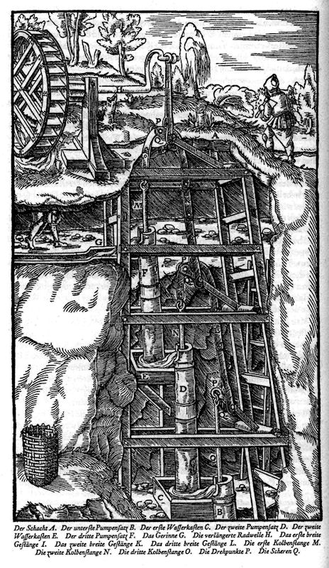
One highlight of the tour is the Kunstgezeug in the Reichelschacht, the old miner term means a wooden system of pumps used to drain the mine. The water is lifted from the sump by a series of 7 m high pumps until the adit is reached, through which the water flows out of the mine with gravity. Here the power source is located, a water wheel, and the water driving the wheel is also flowing out of the adit. To power the wheel, a huge amount of water is needed, which was brought to the mine by a system of canals on the surface. This mine was fed by the Grüner Graben (green canal), which was built between 1678 and 1680.
An exhibition gives some insights into the work of the Wismut SDAG after World War II. The GDR had to pay reparations to the Soviet Union in the form of Uranium. The mining company which was ordered to mine the uranium was named Wismut (bismuth), a Cold War code name. They were not interested in bismuth at all. The mining was reactivated here for some years, but no uranium was found.
There are numerous geotopes inside the mine. It gives an interesting insight into the complex structure of the ore veins.
 Search DuckDuckGo for "Tiefer Molchner Stollen"
 Google Earth Placemark
 Molchner Stolln
  - Wikipedia (visited: 20-FEB-2026)
 :::Molchner Stolln:::, official website
  Index
Index Topics
 Hierarchical
 Countries
 Maps
Maps