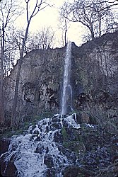
Uracher Wasserfall
Waterfall of Urach
Useful Information
| Location: |
Near Bad Urach.
A8 (E52) exit Merklingen, to Laichingen, turn right on B28 west to Bad Urach. A8 (E52) exit Wendlingen, B297 to Nütingen turn left on B313 to Metzingen, buy clothes at Hugo Boss, turn left on B28 to Bad Urach. Opposite the turnoff to the Bath turn off to Güterstein, parking lot Maisental, 1.5 km walk to the waterfall. (48.482353, 9.368119) |
| Open: |
no restrictions. [2025] |
| Fee: |
free. [2025] |
| Classification: |
 Tufa Deposits Tufa Deposits
 Tufa Runnel Tufa Runnel
|
| Light: | n/a |
| Dimension: | A=623 m asl, VR=37 m. |
| Guided tours: | self guided |
| Photography: | allowed |
| Accessibility: | no |
| Bibliography: | |
| Address: |
Kurverwaltung Bad Urach, Bei den Thermen 4, 72574 Bad Urach, Tel: +49-7125-9432-0.
E-mail: |
| As far as we know this information was accurate when it was published (see years in brackets), but may have changed since then. Please check rates and details directly with the companies in question if you need more recent info. |
|
Description

The Uracher Wasserfall (Urach waterfall) is a typical phenomenon for a karst area: a body of water that builds its own bed. The water of the Urach waterfall rises just a few metres above from a spring that pours karst water. This water is saturated with limestone, which is now deposited above ground. Over the course of time, a mighty plateau of limestone tufa has formed around the spring.
The stream flows in a self-created bed, a stony channel that was formed by deposition, not erosion. This channel is built up by the water; whenever a wave spills over the edge, the water deposits the lime there. If, on the other hand, lime is precipitated in the flowing water, i.e. in the centre, it is immediately carried along by the current. When the stream reaches the edge of the plateau, lime is also deposited at the break-off itself. The stream thus creates a kind of bay, like a spout on a coffee pot, which grows further and further out. But if this projection extends too far, it breaks off under its own weight, raising the pile of rubble at the foot of the waterfall.
The water is the Brühlbach, whose catchment area is the Alb plateau to the south around Würtingen. The source is 623 m asl and has a minimum flow of 70 l/s in summer. When the snow melts or after very heavy rainfall, this can rise to up to 420 l/s. After just 50 m, the stream reaches the waterfall and then flows north along the Maisental valley to flow into the Erms at the end of Bad Urach, near the bathing centre. The water from the spring, almost 2 million cubic metres a year, transports away around 550 t of dissolved limestone every year. However, around 10 % of this is precipitated at the waterfall.
The fact that the spring rises about 90 metres above the valley floor is typical of the karst on the northern edge of the Swabian Alb. Here, the Malm consists of thick layers of limestone, into which clay-rich marl layers are repeatedly embedded. These layers are impermeable to water and thus dam up the water. Where the marl layer is exposed on the valley slope, the karst water emerges from it.
However, the current state is not entirely natural. Originally, the water cascaded down into the valley in several parallel waterfalls. This also makes the formation of the plateau easier to understand. However, calcareous tufa is very easy to work with when it is damp in the mountains and very stable, light and heat-insulating when dry. It was therefore a popular building stone and was also quarried here. The quarried tuff was used, among other things, for the construction of the Amandus Church in Urach. In the course of this quarrying process, the water was channelled to facilitate extraction and a path was built up to the plateau.
- See also
 Search DuckDuckGo for "Uracher Wasserfall"
 Google Earth Placemark
 OpenStreetMap
 Uracher Wasserfall
  - Wikipedia (visited: 19-MAY-2025)
 SAGEN.at - Uracher Wasserfall, Bad Urach
  (visited: 19-MAY-2025)
 Ausflug zum Uracher Wasserfall und der Ruine Hohen Urach
  (visited: 19-MAY-2025)
 Prof. Blumes Tipp des Monats: Naturwissenschaften an den Uracher Wasserfällen
  (visited: 19-MAY-2025)
 Index
Index Topics
 Hierarchical
 Countries
 Maps
Maps