Karstkundlicher Wanderweg Neuhaus/Pegnitz
Karst Trail Neuhaus/Pegnitz
Useful Information


| Location: |
Bahnhofstraße 11, 91284 Neuhaus an der Pegnitz.
A9 exit Plech, through Plech to Neuhaus/Pegnitz. Or by public transport to Neuhaus/Pegnitz station. (49.6344231, 11.5938168) |
| Open: |
no restrictions. [2023] |
| Fee: |
free. [2023] |
| Classification: |
 Karst Trail Karst Trail
|
| Light: | bring torch for caves |
| Dimension: | L=12 km, VR=327, A=380-518 m asl, D=3.5 h. |
| Guided tours: | self guided |
| Photography: | allowed |
| Accessibility: | no |
| Bibliography: | |
| Address: |
Nürnberger Land Tourismus, Landkreis Nürnberger Land, Waldluststraße 1, 91207 Lauf an der Pegnitz, Tel: +49-9123-950-6062.
E-mail: |
| As far as we know this information was accurate when it was published (see years in brackets), but may have changed since then. Please check rates and details directly with the companies in question if you need more recent info. |
|
History
| 04-OCT-1936 | trail inaugurated. |
| 2002 | trail signs renewed. |
| 2004 | explanatory signs added. |
Description


The karst trail from Neuhaus an der Pegnitz has existed for many years.
It was marked in 1936 by the Fränkischen Albverein (Franconian Jura Club), at the suggestion of Richard G. Spöcker, the grand old man of Franconian speleology.
In 2004, however, it was equipped with new explanatory signs that inform hikers about the most important points.
The 13 km long circular hiking trail starts at the railway station in Neuhaus an der Pegnitz and is marked with a green dot in a white field.
It takes four to five hours to walk to the
 Maximiliansgrotte.
show cave, among other places.
The cave ruin
 Vogelherdgrotte
is also on the way.
At Maximiliansgrotte, just under halfway along the trail, you have the opportunity to stop for a bite to eat at the Grottenhof restaurant.
It is also possible to walk only a 4 km section of the Karst Trail from here.
The trail passes a total of ten stations that show the entire spectrum of Franconian and Upper Palatinate karst. In Neuhaus you can see a karst spring with a spring pond and the Hinterbrunnen.
Now the path leads out of the village through a flat dry valley. After a while you reach the small Distlergrotte. Further on, you come to the Mysteriengrotte, which is also only a few metres deep, but has a quite impressive entrance. Via the Schlieraukapelle (Schlierau Chapel) you finally reach the Maximiliansgrotte.
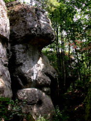
From here, the path leads through the forest to various dolomite rocks. It begins with the Weissingkuppe, which, in addition to picturesque rocks and narrow gorges, has a mushroom rock to offer, where a layer of rock at the foot has almost completely weathered away, so that it only stands on a very narrow foot. Downhill, you reach a characteristic solution doline.
Now the path climbs again to the Steinerne Stadt (Stone City). This popular climbing area is characterised by its unusual rock formations and overhanging cliffs. Gorges with almost vertical walls have formed along fissures in the rock, cave-like passages and faces in the rock make this an almost unreal place.
A little further on we come to the Vogelherdgrotte, a cave ruin that shows the last stage in the development of a cave. And finally we come to the Opfersteine (Sacrificial Stones), another dolomite formation marked by weathering. Now the trail leads through a varied landscape back to Neuhaus.
The official starting point of the trail is the railway station in Neuhaus an der Pegnitz. This is very convenient if you are travelling by public transport. By car, it is helpful to head for a car park, of which there are several in the town. We have given a parking option as coordinates, which shortens the hike by about 1.5 km.
- See also
 Maximiliansgrotte
 Vogelherdgrotte
 Search DuckDuckGo for "Karst trail Neuhaus Pegnitz"
 Google Earth Placemark
 Karstkundlicher Wanderpfad (
 )
) Karstkundlicher Wanderpfad
  (visited: 20-FEB-2023)
 Felsen und Höhlen am karstkundlichen Wanderpfad
  (visited: 20-FEB-2023)
 Neuhaus an der Pegnitz Karstkundlicher Wanderweg zur Steinernen Stadt
  (visited: 20-FEB-2023)
 Index
Index Topics
 Hierarchical
 Countries
 Maps
Maps