Johannisfelsen
Growing Rock - Usterling Tufa Runnel
Useful Information
| Location: |
Mamminger Str. 55, 94405 Landau an der Isar.
Motorway A92 Munich-Deggendorf exit 19 Landau a.d. Isar. B20 towards Landau, cross the Isar, turn right onto the district road to Mamming/Dingolfing, after 3 km in Usterling. Signposted. (48.6625969, 12.6488252) |
| Open: |
no restrictions. [2024] |
| Fee: |
free. [2024] |
| Classification: |
 Tufa Runnel Tufa Runnel
|
| Light: | n/a |
| Dimension: | L=35 m, H=5,40 m, W=70-120 cm, A=360 m NN. |
| Guided tours: | self guided |
| Photography: | allowed |
| Accessibility: | no |
| Bibliography: | |
| Address: |
Tourismusverband Ostbayern e.V., Im Gewerbepark D 02/D 04, 93059 Regensburg, Tel. +49-941-585390.
E-mail: Rathaus Landau a.d.Isar, Oberer Stadtplatz 1, 94405 Landau a.d.Isar, Tel: +49-9951-941-0. E-mail: |
| As far as we know this information was accurate when it was published (see years in brackets), but may have changed since then. Please check rates and details directly with the companies in question if you need more recent info. |
|
History
| 1520 | depicted on the altarpiece of the Usterlingen church. |
| 1579 | first written mention by Apian. |
| 1937 | declared a Natural Monument. |
| 1993 | maintenance work taken over by the nature conservation of the district of Dingolfing-Landau. |
| 2002 | awarded the official seal of quality "Bavaria’s most beautiful geotopes". |
| 2003 | Boards with explanations set up. |
| 2006 | included in the list of Germany’s 77 recognised national geotopes. |
Description
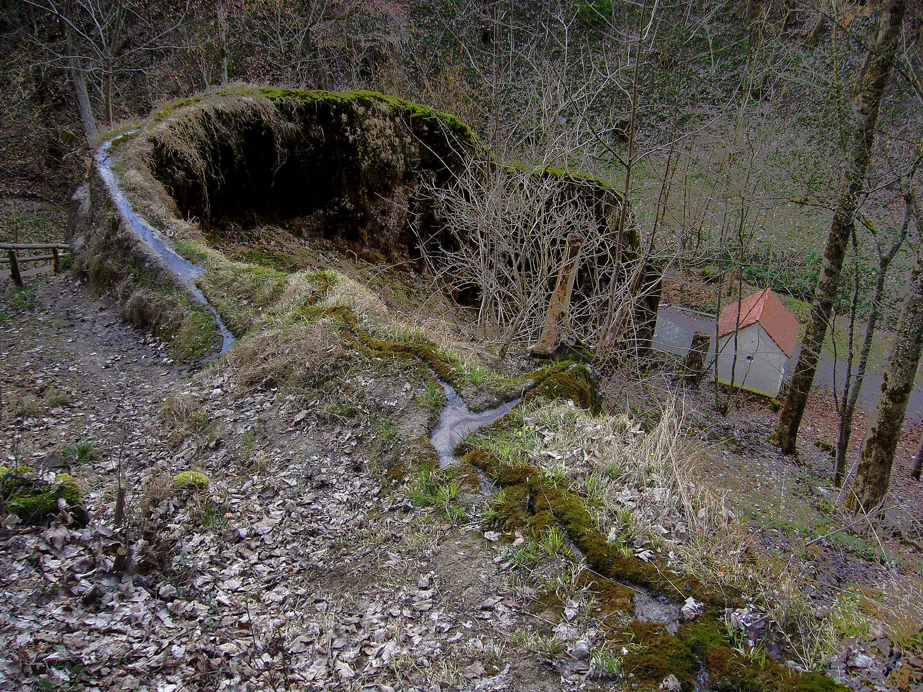
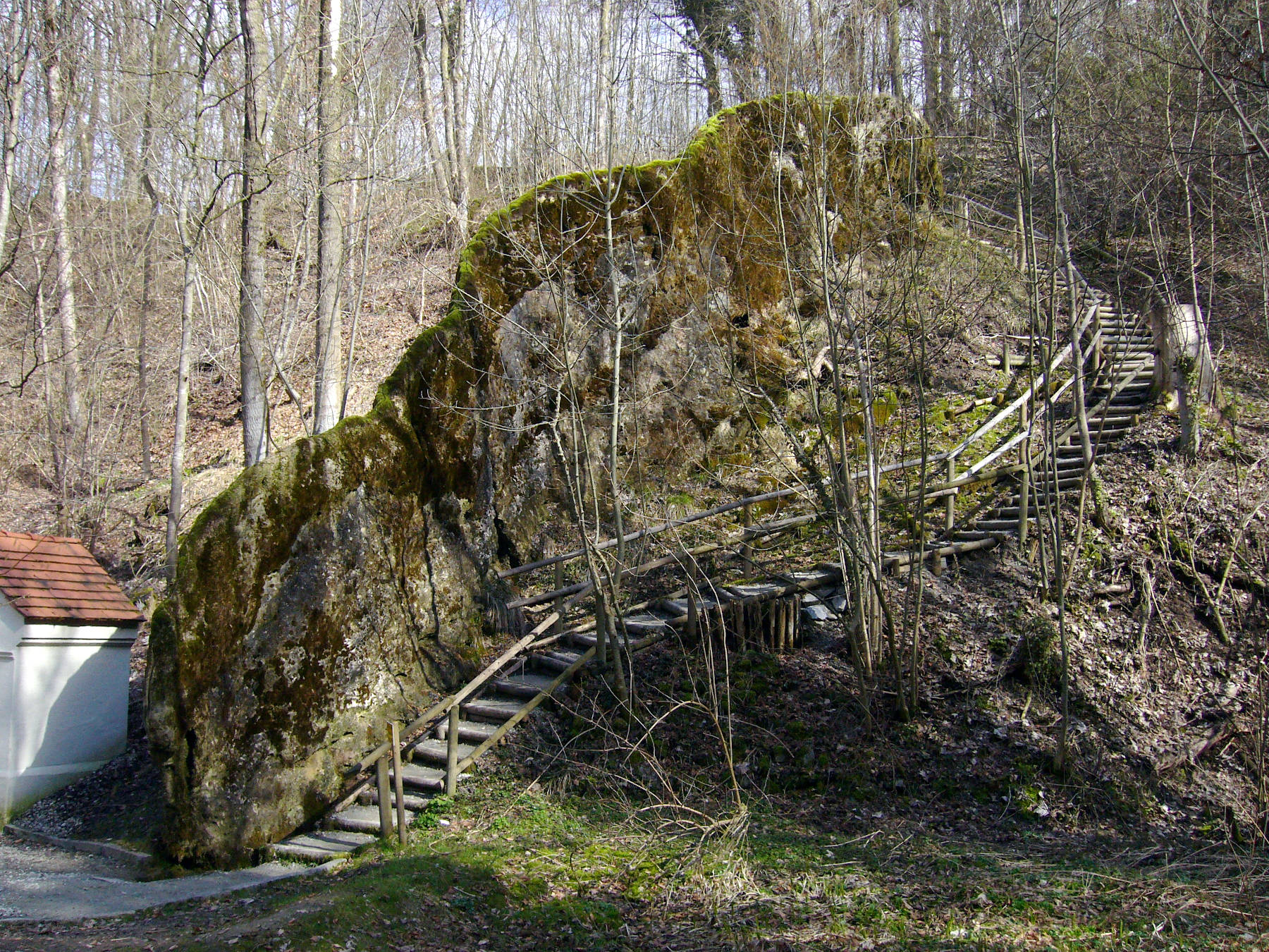
The Johannisfelsen near Usterling is a so-called tufa runnels. The name Johannisfelsen comes from John the Baptist, to whom a wayside shrine with a wooden figure at the foot of the rock is also dedicated. Above the rock there is the Johanniskapelle (St John’s Chapel). It is also known as Wachsender Felsen, Wachsender Stein (Growing Stone) and Steinerne Rinne Usterling (tufa runnel Usterling). The limestone-rich water builds its own bed, thus creating a dam over time, on the crown of which the stream flows in its self-made runnel. At 35 m long, the Johannisfelsen is not very long, but at over 5 m high it is the highest tufa runnel in Germany. However, it is only 70 to 120 cm wide. It is sometimes referred to as the "largest" Steinerne Rinne, but what is meant is that it is the "highest" in Germany. And every year it gets two to three centimetres higher.
In the church of Usterling, the filial and pilgrimage church of St. John, there is an altarpiece from 1520. It depicts the baptism of Christ by John the Baptist, the baptismal water coming from the tufa runnel. The painting was made in 1520 and is the first pictorial representation of the rock, clearly older than the first written mention in 1579. The depiction was probably the reason why the runnel was called Johannisfelsen. The water was said to have healing powers for eye diseases and Usterling was a place of pilgrimage for centuries. Whether the healing powers were the reason for the pilgrimage, or the place of pilgrimage was the reason why healing power was attributed to the spring, can no longer be said today. Even today, people in the area wash their eyes with the spring water on 24 June, St John’s Day. This is a local peculiarity, as eye diseases are not among the patron saints customary "responsilities".
Usterling is one of the place names ending in -ing or -ingen. This form of the name was popular with new foundations from the 7th century onwards, usually the first part of the name was derived from the name of the founder of the place. So one could speculate that the village was founded around the 7th century by someone named Uster and his family or tribe. In fact, the village is mentioned in documents as early as 731 as "Ystilung", when a certain Einpertus and someone called Odelscelch had given the place to the Niederaltteich monastery. In 888, Bishop Ambricho of Regensburg acquires property "ad Usterlüngon und Zullingon". The church in Usterling is first mentioned in 1148 and 1223, the present church is late Gothic and dates from the early 16th century.
The Winged Altar of Saint John, also known as the Usterling High Altar, is one of the most important works of art in the district. It was created by an unknown artist from the circle of Hans Leinberger. It shows the depictions of John the Evangelist and John the Baptist. Opened, the wings of the altar show four other reliefs: the beheading of John the Baptist, the saint’s sermon in the desert, the baptism of Jesus, and a depiction of the Growing Rock. At that time, artists often incorporated local geography into sacred art, the locations were familiar to the faithful and associated with the biblical stories. But it also shows that the church liked to use the unusual geotope as a promotional medium.
Tufa runnels form under favourable conditions, but also decay when conditions change. This gully would probably have decayed by now, or at least would look quite different today, if it had not been carefully maintained. For many generations, the altar servers of the church in Usterling kept the gully free of leaves and soil. In winter, the water was even diverted so that the rock would not be damaged by frost. In the meantime, this maintenance work has been taken over by the nature conservation of the district of Dingolfing-Landau. The geotope is under nature conservation and was presented to a larger public in 2002 in the campaign Bayerns schönste Geotope (Bavarias most beautiful geotopes). On this occasion, updated information boards were also erected on the site.
Usually, tufa deposits and tufa runnels are formed at karst springs. However, this is not a karst area. The deposits of the Obere Süßwassermolasse (Upper Freshwater Molasse) are impermeable marls overlain by slightly consolidated limestone gravels. Groundwater flows through the gravels, the many fissures allow water to flow through and also provide a surface for the dissolution of the limestone. The groundwater is confined by the marls and thus forms a so-called perched water table. A spring formed where the marl/limestone gravel layer boundary was cut by the slope of the Isar River. Since the water does not come from a cave, the flow of the spring fluctuates less than a karst springs. Also, there are no flood events that would pour sediment-rich water and thus disturb the growth of the gully.
The Growing Rock is located on the eastern edge of the village in the forest and is signposted. It can be reached on a short footpath from a small car park on Mamminger Straße, at the end of the village in the direction of Zulling.
 Search DuckDuckGo for "Johannisfelsen"
 Google Earth Placemark
 OpenStreetMap
 Wachsender Felsen
  - Wikipedia (visited: 14-MAY-2024)
 Wachsender Felsen von Usterling
  Index
Index Topics
 Hierarchical
 Countries
 Maps
Maps