Gottesackerplateau
Useful Information
| Location: |
Auenalpe 4, 6992 Hirschegg.
A7 Kreuz Kempten, A980 exit 3 Waltenhofen, B19 via Sonthofen and Oberstdorf to Kleinwalsertal. On the Austrian side B201, at Riezlern follow the signs to Ifen Bahn. Kleinwalsertal, Ifen cable car. (47.365012, 10.104106) |
| Open: |
no restrictions. [2023] |
| Fee: |
free. [2023] |
| Classification: |
 Bare Karst
Karst
Limestone Pavements Bare Karst
Karst
Limestone Pavements
|
| Light: | n/a |
| Dimension: | |
| Guided tours: | self guided |
| Photography: | allowed |
| Accessibility: | no |
| Bibliography: |
Max Eckert (1902):
Das Gottesackerplateau,
Wissenschaftliche Ergänzungshefte zur Zeitschrift des D. u. Ö. Alpenvereins, I. Band, 3. Heft.
pdf
Georg Wagner (1950): Rund um Hochifen und Gottesackergebiet Verlag der Hohenlohe’schen Buchhandlung Ferdinand Rau, Öhringen, 1950. Emil Büchel (2016): Bregenzerwald, In Höhlen und Karst in Österreich, Hrsg. C. Spötl, L. Plan, E. Christian, Oberösterreichisches Landesmuseum, 2016:467-476. Chloé Fandel, Ty Ferré, François Miville, Philippe Renard, Nico Goldscheider (2022): Improving understanding of groundwater flow in an alpine karst system by reconstructing its geologic history using conduit network model ensembles, preprint currently under review for the journal HESS. online DOI |
| Address: |
Kleinwalsertal Tourismus eGen, Walserstrasse 264, A-6992 Hirschegg, Tel.: +43-5517-5114-0.
E-mail: |
| As far as we know this information was accurate when it was published (see years in brackets), but may have changed since then. Please check rates and details directly with the companies in question if you need more recent info. |
|
History
Description
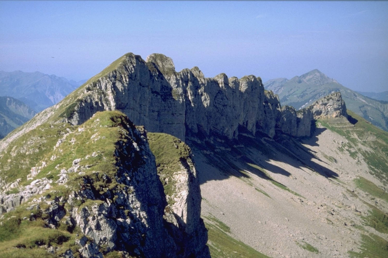
The Gottesacker plateau is located on the border between Germany and Austria, the border is quite idiosyncratic and thus a large part belongs to Germany. In addition, although Kleinwalsertal belongs to Austria, it can only be reached by road from Germany, a so-called functional exclave. It is in fact a gently sloping plateau without any real peaks, bordered to the north by the German Starzlachtal, also called Rohrmoostal, to the east by Kleinwalsertal, to the south by Hohen Ifen, and to the west by the valley of the Schönenbach. We have listed it completely arbitrarily for Germany, actually it should be listed for both countries. This is one of the cases where a political border for a geotope really makes no sense at all. For this reason, the area is also protected together with the Hohen Ifen (2,230 m asl) in the Ifen European Protected Area, not in a national Natural Monument. The whole area is criss-crossed by alpine hiking trails, even though the manifold karst phenomena massively hinder trail construction. Therefore, leaving the paths in this area is strongly discouraged.
The Gottesacker is a so-called bare karst, the rock is not covered by soil and thus has little plant growth. This is very helpful for a geotope, because you can see the rock and the diverse karst phenomena very well. The fact that no plant cover has formed is not only due to the karstification. The high altitude between 1,800 m NN and 2050 m NN also plays its part, the terrain is above the tree line. However, it is by no means a desert; on flat areas and in depressions there is grass growth as well as mountain pines. In between, there is a variety of rare plant species, as well as an extraordinary fauna.
The area is heavily karstified, drainage is underground via karst springs in the side valleys, and the whole area is part of the Rhine catchment area. The plateau is full of caves, but these are all vertical caves, and it is not possible to visit them. However, the Schneckenlochhöhle at the western foot of the plateau is a popular cave trekking cave. The Hölloch shaft cave has achieved a certain notoriety because its exploration history has been recorded several times in documentaries. Gerhard Baur, a German mountaineer, cameraman and mountain filmmaker, made three of them, in 1977, 1994 and 2011. In 2019, an Arte documentary about the cave was also produced. Arte is a bilingual French-German TV station specialized on art (hence the name) and documentaries.
For the normal visitor, however, what is fascinating are not the caves, nor the many daylight shafts on the plateau. What is interesting are the various karren formations and the limestone pavements. Karren are ditches in the surface of the limestone blocks, which are formed by rain water flowing doen the surface. The water flows to the center of the ditch and then downhill, so solution happens mostly in the center and the diches become deeper and deeper. The limestone pavements are similar, cracks in the rock are widened by water flowing into the cracks. In this way, the fissures become crevices and the limestone blocks become a mosaic arranged like a chessboard.
The rock belongs to the Helvetic, which was formed during the Cretaceous, the so-called Schrattenkalk formation. The Helvetic is one of the major geological nappe systems of the Alps. The Schrattenkalk Formation is named after the Schrattenfluh, a mountain range in the Swiss Pre-Alps in the canton of Lucerne. It is famous for forming karren or weathering surfaces which are locally called Schratten. The term Schrattenkalk was coined in 1834 by the Swiss geologist, mineralogist and alpinist Bernhard Studer. The Schrattenkalk has a thickness of about 60 m to 100 m in the Allgäu and Bregenzerwald area, but is thicker in Switzerland.
There is no "official" hiking trail on the Gottesacker, but the easiest access is probably from Kleinwalsertal. At Hirschegg, a road branches off into the Schwarzwassertal valley, which ends at the Ifen cable car. This chairlift takes the mountaineer up a valley to the mountain station at 2,000 m asl, from where both the trail through the Gottesacker plateau to the Sonnenberg (2036 m asl) and to trail to the Hohen Ifen begin. As a geotope, the plateau is of course accessible without restriction. Nevertheless, there are some restrictions; it is strongly advised not to hike here in snow, darkness or bad weather. But all this is nothing new for the mountaineer. Except perhaps the matter of the snow: when it snows, the paths are not recognisable and many shafts are filled with snow. There is danger to life if you cross such a shaft and the soft snow gives way. We recommend visiting between June and October, pay attention to the weather, have full mountain gear and start early in the morning, the tour takes several hours. Mountain gear means: sun protection, rain wear, warm jacket, mountain boots or trekking shoes, drink, food and of course a camera. As there are no caves a torch is not needed.
 Search DuckDuckGo for "Gottesackerplateau"
 Google Earth Placemark
 Gottesacker (Kleinwalsertal)
  - Wikipedia (visited: 27-FEB-2023)
 Index
Index Topics
 Hierarchical
 Countries
 Maps
Maps