Montezuma Well
Useful Information

| Location: |
5512 County Rd 77, Rimrock, AZ 86335.
I-17 exit 293 and follow the signs. (34.6491787, -111.7523042) |
| Open: |
All year daily 8-16:45. Closed 01-JAN, Thanksgiving, 25-DEC. [2025] |
| Fee: |
Adults USD 10. [2025] |
| Classification: |
 Karst Spring Karst Spring
 Cliff Dwellings of the U.S. West Cliff Dwellings of the U.S. West
|
| Light: | n/a |
| Dimension: | Ø=118 m, VR=18 m, Yavg=66 l/s. |
| Guided tours: | |
| Photography: | |
| Accessibility: | |
| Bibliography: | |
| Address: | Montezuma Castle National Monument, P. O. Box 219, Camp Verde, AZ 86322, Tel: +1-928-567-3322. |
| As far as we know this information was accurate when it was published (see years in brackets), but may have changed since then. Please check rates and details directly with the companies in question if you need more recent info. |
|
History
| 1050 | cliff dwellings started by the Sinagua people. |
| ~1400 | dwellings abandoned. |
| 1873 | explored by military doctor Captain Warren Day. |
| 1976 | dive by Dan Lenihan. |
| 2006 | Dave Conlin and Dan Lenihan dive the sinkhole. |
Description


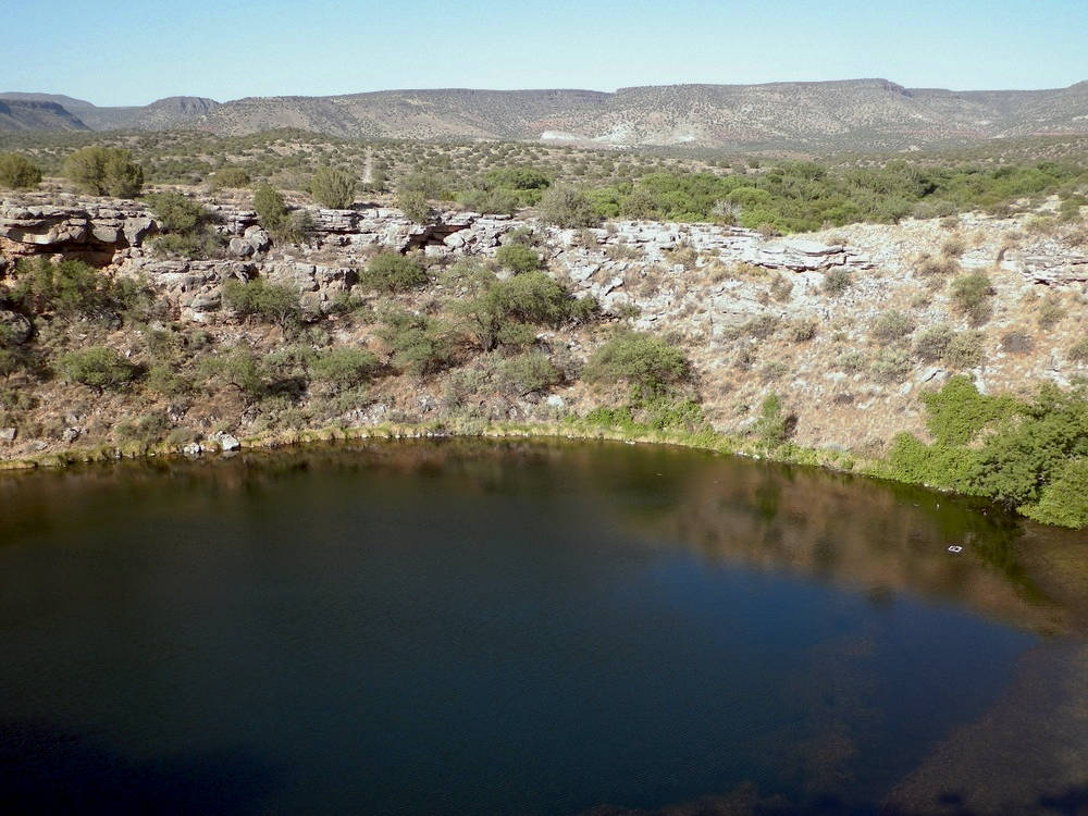
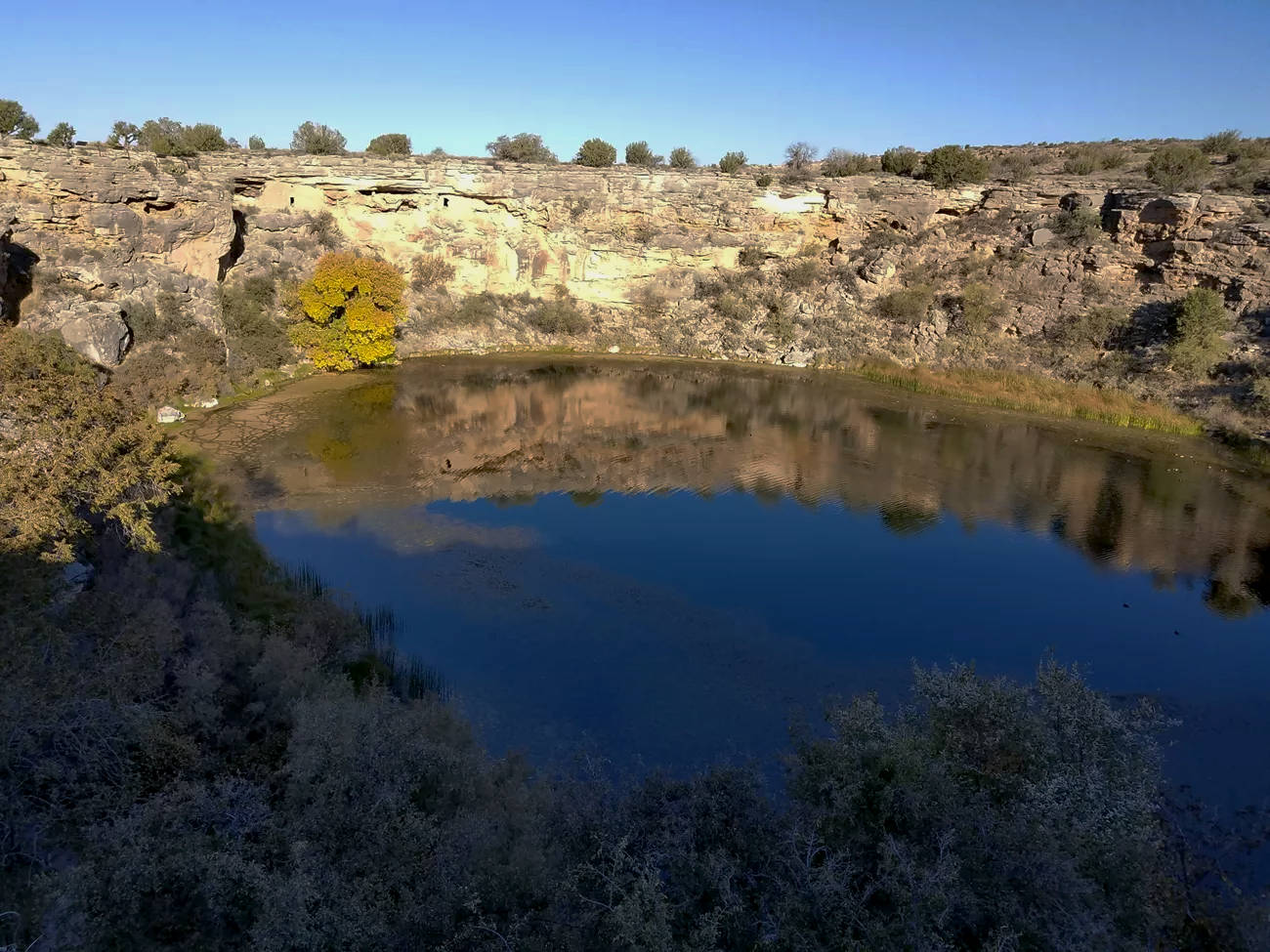
Montezuma Well is a detached unit of Montezuma Castle National Monument, located 18 km north. It was formed by the collapse of an immense underground cavern, in other words it’s a collapsed cave or sinkhole. In Yukatan it would be called a cenote, as it gives access to the groundwater. Two cave passages, or better a cave passage extending on two sides, brings water to the spring, which produces more than 5.6 million liters per day.
Prehistoric Hohokam and Sinaguan cultures made use of this water source to irrigate their crops. Along the spring are the remains of their irrigation canals. The vertical walls of the sinkhole have ledges which were used to build cliff dwellings. Only ruins remain.
This spring was quite mysterious, as no fish seemed to live in it, and any fish people put into it died soon after. Nevertheless, the water was potable and plants grew around the spring. So the local Native Americans said that the well was a place of power. There was a legend that this place was the origin of life on earth. Another quite popular legend said that it was a bottomless lake.
When Captain Warren Day actually explored the spring in 1873 he measured a depth of 19.8 m in the center using a rope as a plumbline. However, the legend was so popular that he refused to publish or even admit his result, to avoid being harassed. However, when the first diver, Dan Lenihan, explored the spring in 1976, he found a lot of leeches in the water and a sort of bubbling or boiling floor. This is actually quite common in springs, water emerging from sand on the floor creates a typical movement of the sand, which is pressed up by the water pressure and then falls back to the ground. But when the diver tried to touch it and stuck his hand into it, and his hand went right through. He was quite astonished and finally stuck his head through the sand. This was quite easy, and he saw perfectly clear water underneath the thin floating sand layer. He also saw speleothems. Unfortunately he did not take pictures, so it was just divers lore, when he talked about his discovery.
30 years later, in 2006, the divers Dave Conlin and Dan Lenihan again dived the sinkhole. However, they were not successful in taking pictures of the lower level, so they only surveyed the upper part. When they tried to cross the sand they found it was solid. The current theory is that there is actually a cave below the sand layer, but not all over the huge sinkhole, ony at a certain point, and Dan Lenihan could not recall where he actually made his discovery. But it is also possible that the sand, which moves quite easily and fast, filled in the cavern. Such things are often dependent on certain climate conditions and amounts of rain, which - as we all know - actually changes rather massive. As the permit for diving was restricted they were not able to search the whole floor. Since then there were no further researches.
One of the main reasons why there is no research, is the fact that the site is a holy site for the Native people which live in the area. These are specifically the four southern tribes of Arizona, the Yavapai, the Apache, the Hopi, and the Zuni. As a result diving is only possible with the blessing of the elders as well as the permit of the National Monument. But visitors who do not dive are allowed if they are respectful, and there is a nearby picnic ground.
- See also
 Search DuckDuckGo for "Montezuma Well"
 Google Earth Placemark
 OpenStreetMap
 Montezuma Well - Wikipedia (visited: 29-OCT-2025)
 Exploring Montezuma Well, official website (visited: 29-OCT-2025)
 What’s Beneath the Bubbling Sand at the Bottom of the Montezuma Well? - Atlas Obscura (visited: 29-OCT-2025)
 Index
Index Hierarchical
 Countries
 Maps
Maps