Devils Punchbowl
Useful Information
| Location: |
Devils Punchbowl State Natural Area, 122 1st St, Otter Rock, OR 97369.
(44.7471588, -124.0648217) |
| Open: |
no restrictions. [2025] |
| Fee: |
free. [2025] |
| Classification: |
 Sea Cave
Sandstone Cave Sea Cave
Sandstone Cave
 Collapse Doline Collapse Doline
 Natural Bridge Natural Bridge
 Geotopes named after the Devil Geotopes named after the Devil
|
| Light: | n/a |
| Dimension: | |
| Guided tours: | self guided |
| Photography: | allowed |
| Accessibility: | no |
| Bibliography: | |
| Address: | Devils Punchbowl State Natural Area, 122 1st St, Otter Rock, OR 97369, Tel: +1-541-265-4560. |
| As far as we know this information was accurate when it was published (see years in brackets), but may have changed since then. Please check rates and details directly with the companies in question if you need more recent info. |
|
History
| 1929 | first land given to the state by F. W. and C. P. Leadbetter. |
| 1930s | Civilian Conservation Corps developed day use improvements for the park, including picnic tables, restrooms, fountains, water supply, fire places, a foot trail and steps to the beach. |
| 1971 | land purchased from other private owners, park expanded. |
Description
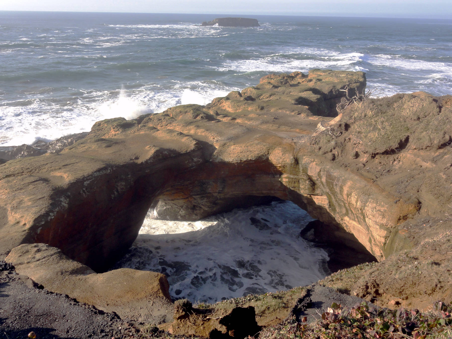
Devils Punchbowl is a strange geological attraction which is hard to classify. Probably it’s best described as a sea cave in red sandstone with a sinkhole. It seems the waves actually eroded a sea cave into a weaker section of the sandstone, along a disturbance in the rock. When the roof of the cave collapsed the cave became a natural bridge, and the collapse doline was enlarged by the waves entering through this natural bridge. The rocks from the ceiling form now the floor of the huge almost circular hole, and due to the water they have become almost black. During low tide the floor is visible, during high tide it is covered by seawater and may be quite spectacular in rough seas, when the waves give the impression that the water is boiling. That’s the reason why this site was named Devils Punchbowl or sometimes Satan’s Cauldron.
Actually there are two openings to the sinkhole, one on the western side which is easily visible from the outlook. The other is on the northern side opening to Otter Crest Beach. The beach as well as the cave are more or less dry during low tide, but you should avoid them during high tide and bad weather. However, the connection between the two caves is not very clear, most likely the formed at the same time and at some point they met. If this happened before the sinkhole collapsed or later is unknown. It’s also possible that it is actually a single cave which was split into two natural bridges by the collapse.
The site is a State Natural Area and freely accessible. There is a parking lot, a seafood restaurant, and an outlook, the park is a popular whale watching site. It’s possible to enter the collapse doline, but there is no trail down. A long wooden slide from the early 20th century and a foot trail and steps to the beach from the 1930s are both removed. Also climbing is not allowed. The best way is to use a kajak from Otter Crest Beach and enter through the natural bridge. At low tide its also possible to enter on foot from the north. They publish the coast tide tables on the official website.
- See also
 Search DuckDuckGo for "Devils Punchbowl"
 Google Earth Placemark
 OpenStreetMap
 Devils Punch Bowl State Natural Area - Wikipedia (visited: 11-NOV-2025)
 Devils Punchbowl (visited: 11-NOV-2025)
 Devils Punchbowl - Atlas Obscura (visited: 11-NOV-2025)
- Devils Punchbowl State Natural Area in Oregon (visited: 11-NOV-2025)
 Index
Index Hierarchical
 Countries
 Maps
Maps