Unška koliševka
Unec Collapse Doline
Useful Information


| Location: |
Planina.
From Postojny follow 409 towards Planina, at Raubarkommanda turn right on 914 toward Unec/Rakov Skocjan, turn left on bridge across the motorway. After some time there is a sign for the doline. (45.815450, 14.265500) |
| Open: |
no restrictions. [2023] |
| Fee: |
free. [2023] |
| Classification: |
 Tiankeng Tiankeng
 Doline Doline
 World War II Bunker World War II Bunker
|
| Light: | bring torch |
| Dimension: | L=160 m, W=110 m, VR=125 m. |
| Guided tours: | self guided, L=1.5 km. |
| Photography: | allowed |
| Accessibility: | no |
| Bibliography: | |
| Address: | Unška koliševka |
| As far as we know this information was accurate when it was published (see years in brackets), but may have changed since then. Please check rates and details directly with the companies in question if you need more recent info. |
|
History
Description


Unška koliševka (Unec Collapse Doline) is a huge hole, almost circular, with vertical wall and debris on the bottom. This is a collapse doline, one of thousands of dolines in this area, but also one of the most spectacular. Here a huge cave chamber collapsed, the debris was carried away by the cave river, and this huge elliptical shaft was formed. It is 160 m long and 110 m wide, and it is at least 125 m deep. So this qualifies this doline as a tiankeng, which is a subgroup of dolines which are more than 100 m in diameter and more than 100 m deep. Unfortunately it is also overgrown and quite hard to see. There is a small car park, big enough for three cars, and some signs. From here a trail goes down into the doline in serpentines.
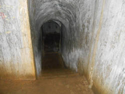
After some time a concrete door is reached which leads into the artificial Jama Unška koliševka, which is, despite the name, not a cave, it’s a bunker. This underground military installation was built by the Italian Army after World War I. After the war Italy had occupied this part of Slovenia, as Austria had lost the war. But the border was right here, the village Planinska was on the other side. So the Italian army tried to build an underground tunnel across the border, which would give them a great strategic advantage. Officially, it belonged to a system of fortifications called Vallo Alpino (Alpine Wall), which included numerous bunkers along the Italian borders from the French border to Slovenia. But they failed, here and also with the other tunnel from Postojnska Jama. And in World War II they lost all the gained land again, and it became socialist Yugoslavia for 45 years.
The bunker and the tunnels here are freely accessible, and quite easy to visit. It only requires a good lamp and good walking shoes for the trail to the entrance. Inside it is mostly level, and either concrete or gravel floor. It is also high enough to walk upright, after all, it was intended for soldiers as a bunker and for transporting people and material across the border. But as Italians were a little shorter then, a helmet is nevertheless a good idea.
This site is quite spectacular, nevertheless it is not listed as a tourist site, there are no advertisements, no info at the tourist info, and it is not listed in guidebooks. This is a little strange, as this is the only tiankeng in the area, and while it is not very well maintained, there is at least a trail and an educational sign, it is an official tourist site. On the other hand, you should definitely not visit the bunker alone. We strongly recommend a helmet, headlamp, reserve lamp, and good walking shoes. Go in a group, in case of an accident, someone can get out to get the cave rescue. There are descriptions which say it’s a 30-minute hike to the site, as it is not allowed to driver there, because the roads are forest roads. The last is actually true, but the gravel roads are very well maintained and rather wide. There are roads all around the doline, but for some reason only one side is actually open for visitors. It’s not a problem, as the site is well signposted. And while we described the access from Postojna, it’s also possible to drive there from Planina or from Unec.
 Search DuckDuckGo for "Unška koliševka"
 Google Earth Placemark
 OpenStreetMap
 Unška koliševka
  - Wikipedia (visited: 10-OCT-2024)
 Unec Collapse Valley (visited: 20-JAN-2023)
 Index
Index Topics
 Hierarchical
 Countries
 Maps
Maps