Rhummel Gorge
Oued Rhummel
Useful Information
| Location: |
Pont des Chutes, Boulevard Zighoud Youcef, Constantine.
(36.370515, 6.615931) |
| Open: |
no restrictions. [2022] |
| Fee: |
free. [2022] |
| Classification: |
 Gorge Gorge
 Natural Bridge Natural Bridge
 Erosional Cave Erosional Cave
|
| Light: | bring torch |
| Dimension: | L=1,800 m, VR=200m, W=4.5 m to 365 m. |
| Guided tours: | self guided, L=800 m. |
| Photography: | allowed |
| Accessibility: | no |
| Bibliography: | |
| Address: | |
| As far as we know this information was accurate when it was published (see years in brackets), but may have changed since then. Please check rates and details directly with the companies in question if you need more recent info. |
|
History
| 4th century BC | city founded by the Phoenician people and named Sewa. |
| 146 BC | city taken over by the Numidian King Syphax and renamed Cirta. |
| 46 BC | becomes a part of the Roman Empire and renamed Colonia Sittlanorum. |
| 311 | city destroyed in a war between emperor Maxentius and Domitius Alexander, a former governor of Africa. |
| 313 | rebuilt and named Colonia Constantiniana or Constantina, after emperor Constantine the Great. |
| 1837 | The last time the city is besieged, by the French army. |
| 1912 | Gantaret El Hibal bridge built, the highest bridge in the world at that time. |
| 2018 | Constantine named “Off-the-radar cities to explore” by the USA Today magazine. |
Description
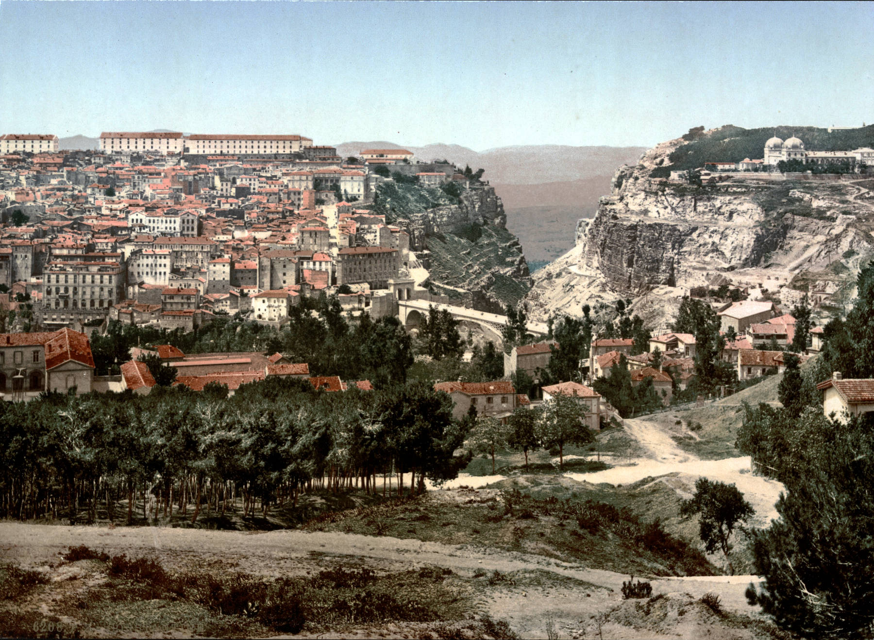
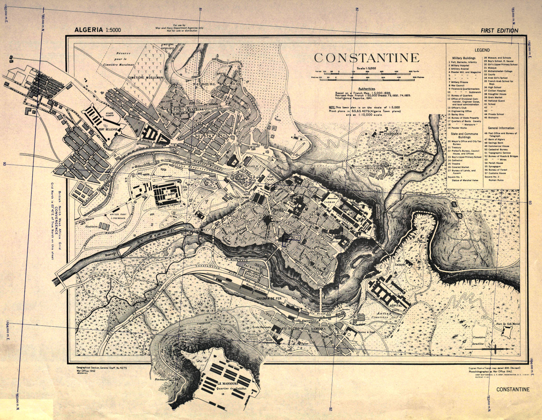
Oued Rhummel (Rhummel Gorge) is located in the city of Constantine, actually it separates the city into two parts, on opposite sides of the deep gorge. It is said to be up to 200 m deep, but actually is about 170 m deep, and its narrowest point in the city limits is about 5 m, but it sometime widens to 350 m. The two parts of the city are connected by eight bridges which are typically 100 m to 150 m long, so that’s the typical width of the gorge at the upper edge. Like most gorges it is narrower at the bottom, and also like most gorges, there is a sort of step in the middle, where it narrows substantially. Unlike most other gorges this step or plateau is also the level of three more bridges, which are natural, and are not mentioned in any description of the city we read.
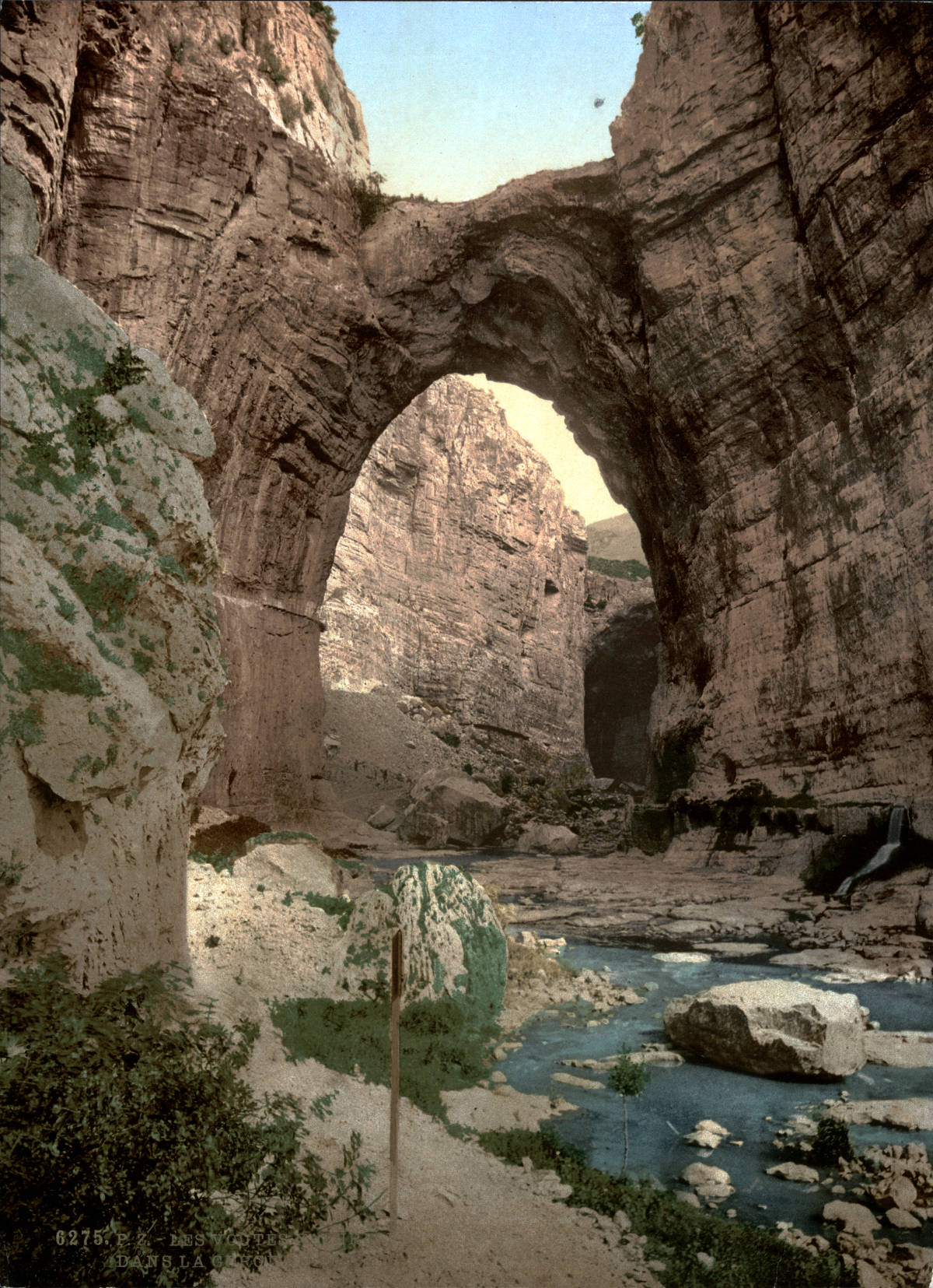
One spectacular feature of the Rhummel Gorge are three natural bridges spanning the river in the lower section of the gorge. The first from the lower end of the gorge is also the largest natural bridge, located more or less below the Sidi n’Cid suspension bridge. The other two bridges are located upstream towards Pont Bab El Kantra. The next is smaller, and the third is even smaller, but very long, it is actually a cave passage. Its upper side is big enough for a park called Jardin El Kantara. As there are trails down to the park from both sides, it is defacto a natural footbridge, the ninth bridge of the city which is never mentioned. The natural brides and numerous other remains of a former cave are easy to recognize. It seems the river once crossed the plateau underground but the cave started to collapse, first with karstfensters here and there, and as they grew the cave vanished and the three natural bridges are all that remains. The gorge is actually a so-called roofless cave.
The gorge has no trail, there are no elevated wooden planks or bridges like in the gorges of Alps. But nevertheless there are various ways to see at least parts of it. The most comfortable is a ride in a car or bus on highway N3 on the northern side of the gorge. It was built into the northern wall of the gorge and descends towards the end of the gorge, then turns right and follows the escarpent descending to the suburb Hamma Bouziane at the foot of the city. Its best if you are not the driver, even better if you are in high vehicle like a bus, and then you should obviously sit on the left side driving downhill.
The most obvious way to see the gorge is to walk across the two already mentioned bridges Sidi n’Cid suspension bridge and Pont Bab El Kantra. They allow a view into the most spectacular part of the gorge. And then there is a path or pedestrian zone along the southern rim called Bd de la Belgique, which allows various views and has several protruding outlooks. It also allows a detour to
And finally there is a rather difficult and unofficial, probably not even legal, way into the gorge. The best starting point is the Pont des Chutes, the bridge across the river at the lower end of the gorge. It was named after numerous waterfalls which are simply called Les Chutes (The Falls). During times of low water, which actually means most of the year except some weeks in winter, it is possible to walk just on the dry part of the rocky river bed. Follow the stream upwards to the three bridges, it’s about 250 m from the road bridge to the first natural bridge, again 20 m to the second, and another 50 m to the third. It’s possible to cross the first two and reach the third, but there are some places which require a little climbing or wading through water. This is far from a canyoning trip, the bigger problem is actually the poor quality of the river water which is like sewage, obviously the locals have no idea what sewage plants are for. Gum boots or at least neoprene water shoes are definitely a good idea. If you want to enter the third bridge a lamp is helpful.
The gorge is actually the part of the city which was inhabited first. The caves at the walls contained numerous prehistoric remains. The city was founded by the Phoenicians, who called it Sewa (royal city). We know about the competing empires of the Phoenicians and the Romans, and the Punic Wars. After the Phoenicians aka Carthaginians (after their Capital city Carthage) were defeated by Rome in the Third Punic War, the Berber Kingdom of Numidia occupied the city in 146 BC and renamed it Cirta or Kirtha. Wars continued and Roman generals Quintus Caecilius Metellus Numidicus and Gaius Marius used the city as a base in their war against the Numidian King Jugurtha. It became a part of the Roman Empire around the year 46 BC and was renamed Colonia Sittlanorum. Julius Caesar gave special rights to the citizens of the city and it became head of a confederation of four Roman colonies on the North African coast. The city was destroyed in a war in 311 and rebuilt two years later, and renamed Colonia Constantiniana or Constantina, after emperor Constantine the Great. Its location makes it easy to defend, on a plateau surrounded by steep cliffs, and it is a walled city. The American map above shows that it was originally only on the left side of the river, with the gorge on two sides and the escarpment on the third. Nevertheless, it was besieged 82 times in its history, the last time was in 1837 by the French army. Today the city has almost half a million inhabitants, a massive growth which happened since the 1950s. Its name is actually not Constantine, that’s just for tourists, its name is قسنطينة (Qacentina, Kasantina).
 Search DuckDuckGo for "Rhummel Gorge"
 Google Earth Placemark
 Rhumel River - Wikipedia (visited: 04-NOV-2022)
 The Natural Arches of Constantine (visited: 04-NOV-2022)
 Index
Index Topics
 Hierarchical
 Countries
 Maps
Maps