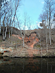
Lībiešu upuralas
Liv Sacrificial Caves
Useful Information
| Location: | Near Kuiķule, Salacgrīva region, 8 kilometers from Svētciems and 10 kilometers from Salacgrīva. (57°42′59″N, 24°29′23″E) |
| Open: | no restrictions. [2020] |
| Fee: | free. [2020] |
| Classification: |
 sandstone cave
red middle Devonian sandstone sandstone cave
red middle Devonian sandstone
|
| Light: | bring torch |
| Dimension: |
Great Sacrifice: L=46 m. Small Sacrifice: L=19 m. |
| Guided tours: | n/a |
| Photography: | allowed |
| Accessibility: | no |
| Bibliography: |
Laime Sandis, Urtāns Juris (2016): Svētupes Lībiešu Upurala Jelgava: Nordik, 2016. 4. – 5.lpp; 10. – 13.lpp ; 15.lpp ; 22.lpp ; 98. -101. lpp. ISBN 978-9984-854-76-2 Sandis Laime (2018): Offering Cave of the Livs in Latvia - from Sacred Place to Tourist Destination, In book: Zbornik Instituta za Arheologiju, vol. 10: Sacralization of Landscape and Sacred Places (pp.383-392). Publisher: Institut za arheologiju (Zagreb, Croatia). Project: Vidzeme’s Svētupe in Mythical and Real Cultural Space. researchgate.net |
| Address: | Lībiešu upuralas, LV-4054 Kuiķule, Salacgrīvas pagasts. |
| As far as we know this information was accurate when it was published (see years in brackets), but may have changed since then. Please check rates and details directly with the companies in question if you need more recent info. |
|
History
| 17th century | first written mention. |
| early 19th century | visited and described by several scholars. |
| 15-AUG-1839 | visited by Friedrich Kruze, professor of history at the University of Tartu, who later published the oldest known image of the cave. |
| 20-JUN-1846 | explored and descibed by Anders Jūhāns Šēgrēns. |
| 1967 | declared an archeological monument of national significance. |
| 1970 | naturalist and local historian Guntis Eniņš surveyed and explored the cave, its inscriptions, and its surroundings. |
| 2001 | included in the list of protected geological and geomorphological natural monuments. |
Description


The Lībiešu upuralas (Liv Sacrificial Caves) are two tiny caves at the right bank of the Svētupe river. The erosional caves, the Great and the Small Sacrifice, were created by flowing water, most likely by a spring which washed the sand out. So the active phase of the cave, the phase of cave formation was when the spring was flowing and enlarging the cave. At some point the spring became dry and the water stopped flowing, and the cave started to collapse slowly. Continuous decay covered the floor with a layer of red sand, which also covered any items the locals brought into the cave. The cave originally had one entrance and various branches inside. Probably in the early 19th century the entrance collapse and two branches of the cave became the currently known two caves. The vestibule was quite spacious and a reason why the cave was visited by many people. After its collapse only two small and difficult to access branches remained, and the number of visitors dropped.
While the tiny caves are not very interesting from the speleological viewpoint, they are quite important from the archaeological view. The cave contained 50 cm of sand with no archaeological remains and 85 cm which were full of remains, mostly offerings by the Liv which inhabited the area. The Livonians or Livs are a Balto-Finnic people indigenous to northern Latvia and southwestern Estonia. Today their culture is almost lost, only a dozen people speak their language. The cave was explored and excavated during the 1970s and became the main archaeological site for the Livs.
There are numerous legends about the cave, which can be divided into three thematic groups. The first group claims that the caves are much longer than they actually are, a common legend told about many caves all over the world. The second group claims that the caves are home to the devil, again quite common. But the third group tells that the caves were an ancient Liv shrine, and are supported by the archaeological evidence.
 Search DuckDuckGo for "Lībiešu upuralas"
 Google Earth Placemark
 Lībiešu upuralas
  (visited: 07-APR-2020)
 Index
Index Topics
 Hierarchical
 Countries
 Maps
Maps