Torghatthullet
Torghatten Cave
Useful Information

| Location: |
Sekundær Fylkesveg 54, 8900 Brønnøysund.
Thorgatten mountain on Torget island, south of Brønnøysund. E5 turn west on 76 to Salhus/Brønnøysund. (67.840771, 12.822296) |
| Open: |
no restrictions. [2023] |
| Fee: |
free. [2023] |
| Classification: |
 Sea Cave Sea Cave
 Natural Bridge
Through Cave Natural Bridge
Through Cave
|
| Light: | n/a |
| Dimension: | L=158 m, H=35 m, W=20 m, A=105 m asl. |
| Guided tours: |
self guided, D=90 min. V=35.000/a [1999] |
| Photography: | allowed |
| Accessibility: | no |
| Bibliography: |
David St. Pierre (1994):
A preliminary bibliography of Torghatten cave, Norway,
Norsk Grotteblad nr.29, Dec 1994, pp 18-19.
|
| Address: |
Brønnøysund Tourist Information Office, Sømnaveien 92, 8900 Brønnøysund, Tel: +47-7501-8000.
E-mail: |
| As far as we know this information was accurate when it was published (see years in brackets), but may have changed since then. Please check rates and details directly with the companies in question if you need more recent info. |
|
History
| 06-MAY-1988 | Widerøe Flight 710 from Namsos to Brønnøysund crashed into the side of the mountain, and all 36 passengers and crew died. |
Description

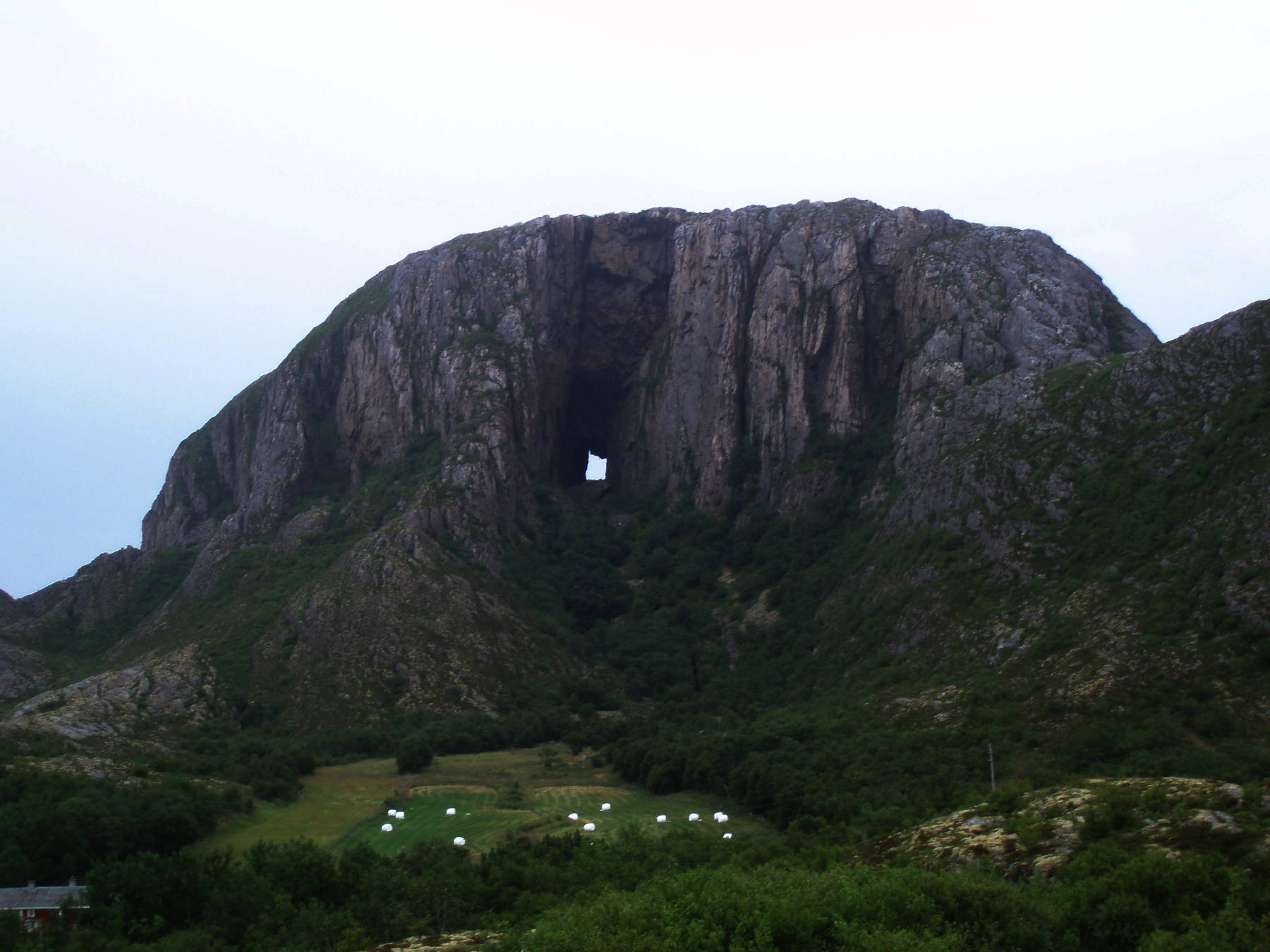
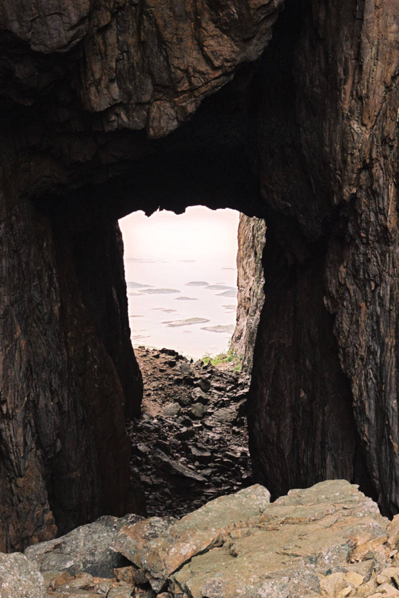
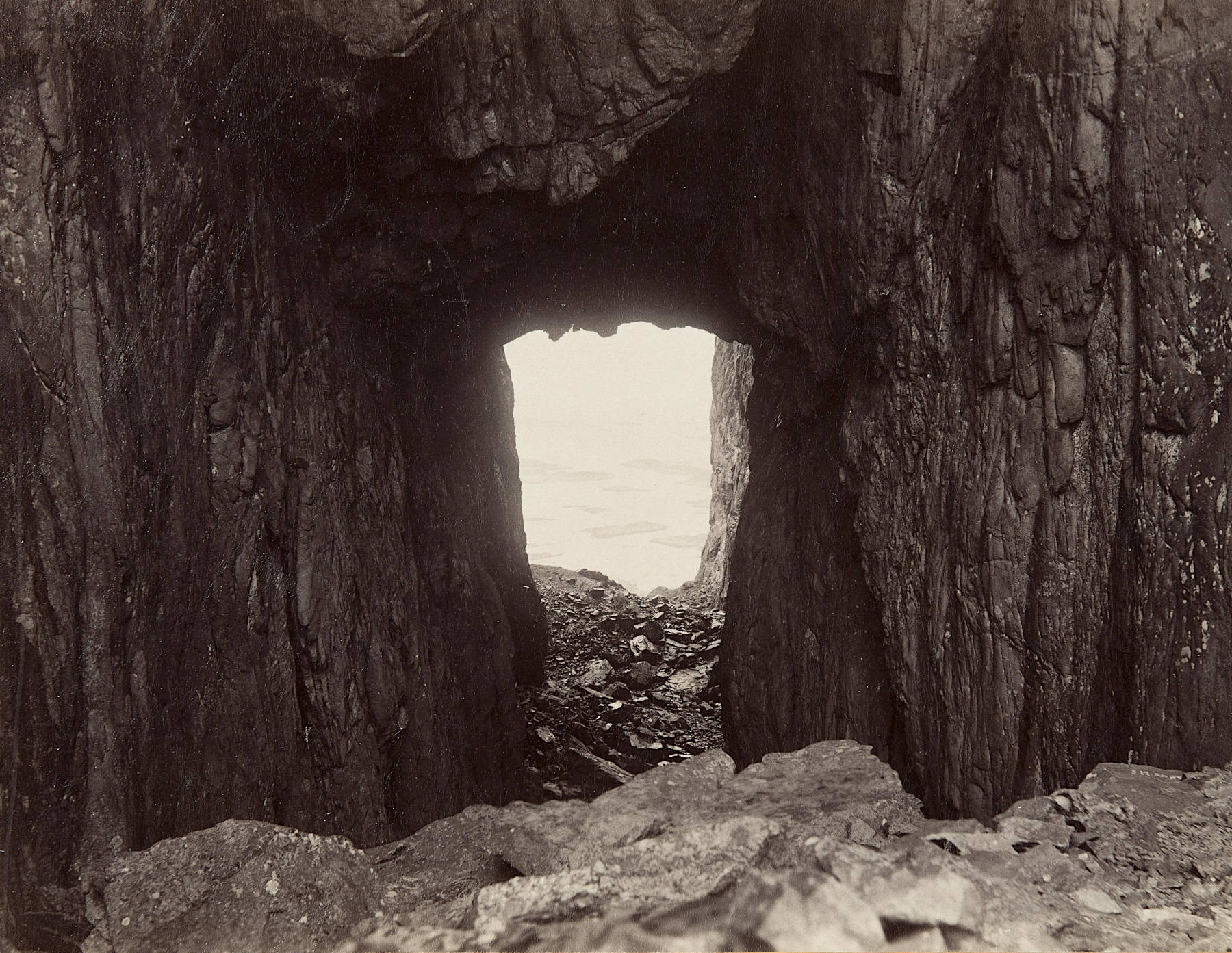
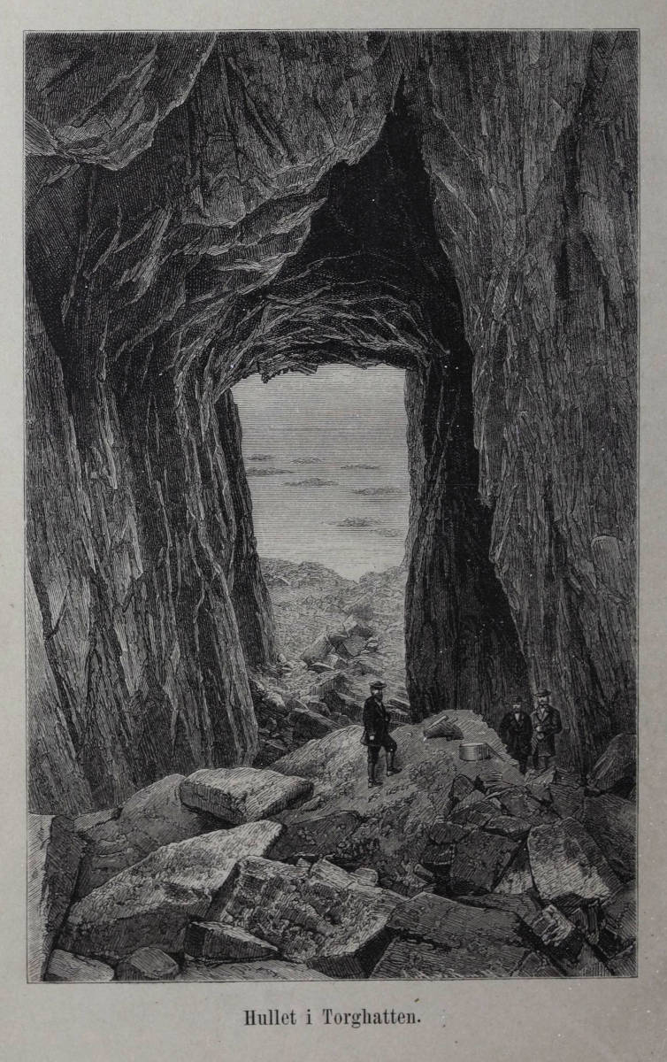
Torghatthullet (Torghatten Cave) is a huge through cave, running right through the monolithic Torghatten mountain. Torghatten translates market hat, because its shape is similar to such a hat. This is probably the reason for the legend which is told about the mountain, see below.
In Hålogaland, in the north, there were two powerful kings: Vågakallen and the King of Sulitjelma.
Their kingdoms were separated by the Vestfjorden, and both had their troubles.
Vågakallen had a disobedient son named Hestmannen (Horseman) and the King of Sulitjelma had seven unruly daughters.
These he sent to Landego, where the beautiful Lekamøyen (Maiden Leka) lived.
One evening the Hestmannen saw the seven sisters and Lekamøyen bathing in the sea near Landego.
A single glance and he was seized by a fervent longing for Lekamøyen, and he decided to rob her at midnight.
On horseback and in full armour with the cloak over his mighty shoulders, he chased southwards.
The maidens discovered him and fled in haste until they had no strength left and surrendered at Alstahaug.
Only Lekamøyen continued alone to flee southwards, while the King of the Sømna Mountains, east of Brønnøysund, watched the wild flight.
As day approached on golden clouds, the Sømna king saw the disappointed suitor Hestmannen draw his bow.
As the arrow flew from the bow, the Sømna King threw his hat in the way, saving Lekamøyen.
The pierced hat fell down near Torgar.
At the same moment the sun rose and everything turned to stone.
Lekamøya is also the name of a rock formation in the municipality of Leka in Trøndelag county, 45 km to the southwest. The rock is 124 m high, and it is a characteristic seamark. From the southeast, it looks like a woman. This is the topic of a different version of the same legend.
Lekamøya was one of King Sulitjelma’s seven daughters. She was approached by the Horseman and fled south to escape. On Leka, she tripped and lost the buttermilk, hence the characteristic red color of the mountains on Leka. At the same time the sun went down, and all the giants turned to stone.
The protagonists are giants or trolls, their hats are 250 m high, they shoot arrows over a distance of 150 km, and their arrows have a diameter of 20 m. And they have a weakness, well known by any reader of E.R.R. Tolkiens The Hobbit: they turn to stone in the daylight.
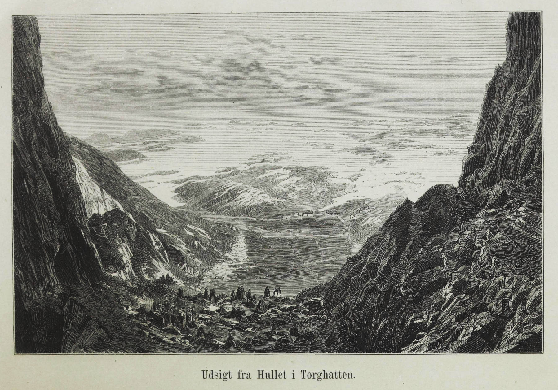
The cave is located on a peninsula near Brønnøysund, and very famous among Norway tourists. It is a special place, with an impressive aura, the view from inside the cave is exceptional, in both directions. Even the Hurtigruten, the Norwegian post ship company, uses the place in a flyer, showing the cave in a photograph of one of their ships right in front of the cave.
The reason for its dome-like rounded form is that it is a granite diapir, which was eroded. Granite is typically harder than the surrounding rock, so it is eroded slower and forms a hill or dome. The granite is formed by an intrusion of magma which does not reach the surface. Insulated by the surrounded rocks, it cools very slowly, and so the three main components, feldspar, quartz and mica, separate by crystallizing one after the other during thr cooling. As a result granite has minerals of decent size but no layering.
But later there was tectonic movement which created a shear zone with at least two main cracks and probably many small ones. As a result, the granite in this vertical section of the dome was fractured and easier to erode. Once the sea level was where the cave is today, and the waves crushing at the granite removed the material from the fracture zone creating a sea cave on both sides of the island. The caves finally met and went through the whole diapir. As the cave is 105 m high above sea level today, there must have been an uplift since then. During the last Cold Age Scandinavia was covered by 3.5 km of glaciers. The weight of this ice pressed the rocks deeper into the mantle, like a heavy freight makes a ship swim deeper in the water. After the melting of the glaciers the weight was gone, and the rocks started to move upwards, like a ship which is unloaded. However, rocks are moving slowly, and so this took some time, and is still ongoing. Modern satellites are able to measure the speed of this movement.
In other words, the area was covered by glaciers until about 12,000 to 10,00 years ago. As soon as the ice was gone, the cave was formed, so it is 12,000 years old. The rock moved up until the cave reached its current location. And it moves up every year a few more centimeters.
The mountain became quite infamous in 1988, when a plane crashed on the mountain, and all 36 passengers and crew died. This became known as Widerøe Flight 710 and Torghatten-ulykken (Torghatten Accident). This was the deadliest accident involving the Dash 7 and the deadliest in Northern Norway. And it is also quite mysterious, as there was no technical failure and actually no reason for the accident. The plane planned to land on Brønnøysund Airport, and it started the descent too early. This would have been no problem at sea, but when the plane arrived at the mountain, it was only 170 m asl, and the mountain is 258 m asl high. Descending 8 miles from the airport instead of 4 miles was a pilot error, the mountain was invincible due to fog. There was no single cause, but it seems the Widerøe airline had massive shortcomings in their operating procedures, in particular lack of proper cockpit communication and mutual control of the descent and approach plans.
This place is not developed at all, but it is very easy to visit. Because of its size, there is no place without light, and there is a trail to the cave and through the cave to the other side. However, during the summer holiday season, it is rather hard to be on your own for a few minutes, as it is visited by most foreigners which come to this area. The hardest thing is to get to Brønnøysund, which is very remote.
 Search DuckDuckGo for "Torghatten"
 Google Earth Placemark
 Torghatten - Wikipedia (visited: 22-FEB-2026)
 Torghatten - the mountain with a hole through it (visited: 22-FEB-2026)
 by Franz Lindenmayr (visited: 22-FEB-2026)
 Index
Index Topics
 Hierarchical
 Countries
 Maps
Maps