Καταβοθρες Καφιας
Kápsia Ponors - Kápsia Cave
Useful Information
| Location: |
Mantinia 221 00.
Kapsas (Kapsia), Mantinía. At the main road from Tripolis to Patras. 15 km from Tripoli and 1.5 km from Kapsia. (37.623862, 22.353995) |
| Open: |
All year Mon-Fri 9-15, Sat, Sun 9-21. [2020] |
| Fee: |
Adults EUR 6, Children EUR 2, Students EUR 2, Reduced EUR 5, Unemployed free, Disabled free. [2020] |
| Classification: |
 Karst Cave Karst Cave
 Ponor Ponor
 Polje Polje
 Karst Lake Karst Lake
|
| Light: |
 Electric Light Electric Light
|
| Dimension: | A=620 m asl. |
| Guided tours: | D=1 h, L=330 m. |
| Photography: | |
| Accessibility: | no |
| Bibliography: |
N.-A. Sidéridès (1911):
Les Katavothres de Grèce,
Spelunca, Bulletin et Mémoires de la Société de Spéléologie, Tome VIII. Nos. 63 et 64. Mars-Juin 1911.

Gustave Fougères (1898): Mantinee et L’Arcadie Orientale, Paris, Ancienne Librairie Thorin et Fils, Albert Fontemoing, Éditeur. Libraire des Écoles Françaises d’Athènes et de Rome, du Collège de France, de l’École Normale Supérieure et de la Société des Etudes historiques. online  E.A. Martel (1894):
Les Abîmes,
Paris, Librairie Charles Delagrave, 1894.
Google Books E.A. Martel (1894):
Les Abîmes,
Paris, Librairie Charles Delagrave, 1894.
Google Books
|
| Address: |
Kápsia Cave, Mantinia 221 00, Tel: +30-2122-149533.
E-mail: Ephorate of Palaeoanthropology and Speleology, Ardittou 34b, Athens 11 636 GR, Tel: +30-21-0923-2358. E-mail: |
| As far as we know this information was accurate when it was published (see years in brackets), but may have changed since then. Please check rates and details directly with the companies in question if you need more recent info. |
|
History
| 1887 | discovered by French archaeologist Gustave Fougères while conducting excavations for ancient artefacts in the wider area of Mantineia. |
| 20-AUG-1892 | first explored by the Greek engineer Nikolaos Sideridis and the French Ch. Gadouleau and J. Valiche. |
| 1911 | exploration published in Spelunca. |
| 1974 | explored by I. Ioánnou and a group of Greek and French speleologists and new parts discovered. |
| 10-OCT-2010 | opened to the public. |
| NOV-2020 | speleologists find a connection to nearby Cave Tousi. |
Description
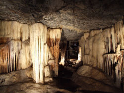
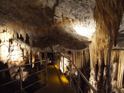
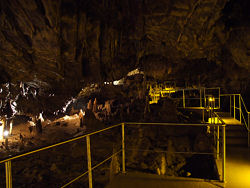


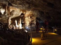
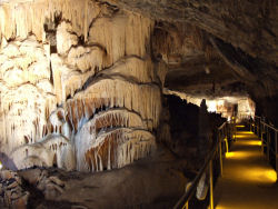
The Σπήλαιο Κάψια (Kápsia Cave) is quite popular, and actually it is one of the most beautiful caves in Greece. It is frequently listed on top ten lists of Greek caves. It consists mainly of a single chamber, which is called Grand Salle des Merveilles (Great Hall of Miracles). The 330 m long trail makes a huge circle in this chamber, which is 60 m wide, 70 m long, between 4 and 10 m high, and full of speleothems. The development ist quite new, the cave was opened to the public in 2010. And it is very popular, there are numerous enthusiastic reviews on the web. Our page is still titled Καταβοθρες Καφιας (Kápsia Swallow Holes), because we created it 20 years ago when the cave was not a show cave, and the only thing which could be visited was the ponor.
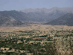
The huge polje of Mantinía is a plain at an altitude of about 620 m asl, surrounded by mountains up to 200 m higher. During winter rains fall in the area, the typical mediterranean winter-rain-climate. The water is drained in reactivated river beds on the surface, until it reaches the Katavothres (swallow holes). Here the water vanishes into huge caves and drains underground. When it reaches plains like this one it reappears in karst spring, flows above ground or sometimes forms huge lakes by flooding the whole plain, and then it vanishes again underground in the middle or on the other side of the polje. And finally the water flows underground to the southeast, to the Mediterranean Sea, where it reappears in huge karst spring under the sea or at the shore of the gulf of Argolis.
The swallow holes, kathavothres, are located all around the plain, and it is essential, that they are free all the time. When they are blocked by rubbish, the plain is flooded and fields are getting too wet, sowing is delayed, and probably even villages are flooded. Because of this, the locals built dams around the kathavothres and gratings into the canal to filter rubbish out of the water. The gratings are cleaned regularly, and so rubbish does not flow into the cave and does not cause congestions.
The kathavothre near Kapsia looks like a fortress at the foot of the mountain slope, and encloses two cave entrances. Kapsia is unique as there is the possibility to visit a cave behind the ponor during dry season, between spring and autumn. The main swallow hole is located in the center, with a canal leading to it. At the cliff face behind are two more cave entrances, which are a higher level of the cave. They are still flooded almost every year but are not the main discharge. The main discharge is a daylight shaft in front of the cave entrances at the bottom of a shallow doline.
Before the cave was developed as a show cave it was possible to visit a part of this upper cave, it is a rather harmless horizontal passage with many speleothems. There had been visits during antiquity, but only very few and also only very few archaeological remains were found. The modern discovery was in 1887 by the French archaeologist Gustave Fougères while conducting excavations for ancient artefacts in the wider area of Mantineia. While he is generally considered the discoverer of the cave, he actually writes in his book published 1898:
Aux grands katavothres de Kapsia et de Tsipiana, je n’ai pu pénétrer à plus de 10 à 15 mètres de profondeur, au-delà de la caverne d’entrée.
Le reste n’était qu’un boyau infect où l’on s’enlisait dans une boue noire.
Voy. les coupes et profils des galeries explorées par M. Sidéridis dans le livre de M. Martel: Les Abîmes, ch. XXVIII.
At the big katavothres of Kapsia and Tsipiana, I could not penetrate more than 10 to 15 metres deep, beyond the entrance cavern.
The rest of the cave was a vile gut where one was stuck in black mud.
See the sections and profiles of the galleries explored by M. Sidéridis in the book by M. Martel: Les Abîmes, ch. XXVIII.
So this is a little confusing referencing back and forth.
It seems Fougères visited the site and explored the entrance for archaeological remains, but he was no caver and the mud from the frequent floods stopped him from entering.
In 1891 the famous
 E.A. Martel
came to Greece to explore the katavothres, and noticed their location at the rims of poljes, which he called kesselthäler.
But he got ill with fever and was only able to explore three of them, and when he met Nikolaos Sideridis, a young Greek engineer, in Tripolis, he lent him all the equipment for exploring caves like rope ladders, dismountable boat, ropes, telephones, etc.
The Greek government was interested in exploring the hydrogeology of the area because of its importance for agriculture and acquired this equipment and entrusted it to Mr. Sideridis.
So both, Martel and the Greek government entrusted Sideridis with a mission.
In the following year, in 1892, Sideridis and the French Ch. Gadouleau and J. Valiche, explored Kapsia.
They surveyed the cave and Sideridis sent his results back to Martel, who published them in chapter 28 Les Katavothres du Péloponèse of his most famous and popular book Les Abîmes in 1894.
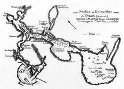
The French names of the cave parts, including Grand Salle des Merveilles, were either dubbed by the French team members or were a French translation in Martel’s book.
The maps we have on this page were published first in this book as foldouts between pages 495 and 496.
For completeness sake: Gustave Fougères published his archaeological discoveries six years later, in 1898, in a book. That’s why he references back to Sideridis and Martel. And additionally to the excerpts in the popular-scientific book by Martel, Nikolaos Sideridis published his complete results in 1911 in two parts with the title Les Katavothres de Grèce. These were volumes of the legendary French caving magazine Spelunca, Bulletin et Mémoires de la Société de Spéléologie. This publication was published since 1896 by Martel and was the most renowned speleological journal of the time.
Many recent show cave descriptions mention this fact, stating that "the official announcement of this cave treasure ... signals global interest in the Greek caves". That’s obviously nonsense, Spelunca is a speleological scientific magazine, and relevant only to the scientific world, and by that only to the geo sciences interested in caves. Nevertheless, this publication is a milestone in the exploration of the underground drainage of Arcadia. The cave became known to ordinary people because of the publication in Les Abîmes in 1894, a book which was reprinted numerous times due to the enormous public interest in caves.
The situation which was described by Martel persisted until the development of the show cave in the late 1990s. Both natural entrances lead to the same passage inside, the main passage goes to the left, after some time turns right, later again right. Brown dirt at the walls shows how high the cave is regularly flooded. The lower speleothems are covered by dirt, the upper are beautifully white. Interesting is the partial flooding of bacon rinds, which are quite fragile, but they are not broken, which tells us that the water does not flow very fast through this cave. And the watermarks show us that the water level never reaches the ceiling. Finally, we reach the main passage of the cave with a huge chamber and someside branches. The biggest chamber is the Grand Salle des Merveiles (Great Hall of Wonders) which is today the show cave part. Although the main passage goes north-south, the drainage goes to the southwest, to the Mediterranean Sea. So the lower level, which is inaccessible, obviously has a different structure.
There was an attempt in the 1990s to open this cave for tourists, but it failed. It took many years, and as it seems massive funding by the EU, to complete the development of the cave and finally open it to the public in 2010. The trails have railings of stainless steel, obviously a gift by the EU development fund. There is an entrance building with ticket office and an exhibition of the archaeological remains. Then there is a short entrance tunnel into the cave. A huge parking lot for the visitors and on the other side a restaurant and hotel. The original ponor is still there, and there are still floods during winter, covering the valley floor with a lake. In other words, it was necessary to build road and parking lot high enough, so they are not affected by the floods. It was necessary to optimize the ponor, to make sure the show cave is not flooded, and it is necessary to keep all the ponors open at all times. While there still remains the danger of a flood, as far as we know the cave had no incident in more than ten years of operation, and it is open all year.
We have visited the cave in 2002, while it was still in development, and were not able to go inside the gated cave. A few years later a team of cavers went there to explore the cave, and they were actually able to see the cave. They met some craftsmen working at the cave and were allowed to take pictures of the completed but not opened cave. That’s why on our pictures show cavers in full caving gear visiting the show cave, which is almost completed. It took two more years until it was finally opened to the public, probably due to bureaucratic problems, as you can see trails and light were already in place two years before.
The cave is located 2 km from the village Kapsia, a new road was built to the show cave through the plain. Following the road 800 m further a second katavothre or swallow hole is reached, which is also worth a visit. It is a pothole in the plain at the foot of the hill, surrounded by a low wall. It’s a 20 minutes detour which is definitely worth the effort.
- See also
 Search DuckDuckGo for "Kápsia Cave"
 Google Earth Placemark: Kápsia Cave
 Google Earth Placemark: Kápsia Swallow Hole
 Σπήλαιο Κάψια
  - Wikipedia (visited: 26-APR-2023)
 Σπήλαιο Κάψια – Κάψια Αρκαδίας, official website
  (visited: 26-APR-2023)
 Σπήλαιο Κάψια | Kapsia Cave with drone | Arkadia-Greece YouTube (visited: 26-APR-2023)
 KAPSAS - location in (GTP) Greek Travel Pages (visited: 26-APR-2023)
 The Kapsia Cave in Arcadia (visited: 26-APR-2023)
 Index
Index Topics
 Hierarchical
 Countries
 Maps
Maps