Σπηλαια Διδυμων
Spilaia Didymou - Didyma Caves
Useful Information
| Location: |
Near Didyma on the Argolis peninsula.
From Nafplio main road to Epidauros. 1 km before ancient Epidauros turn right to the south. Good road to Didyma. At the town turn right at signs. From the south (Pórto Chéli) 24 km north on the national road, turn left at Didyma. The big doline is eas to see from the south. 500 m paved road to the parking. (37.469914, 23.167877) |
| Open: |
no restrictions. [2022] |
| Fee: |
free. [2022] |
| Classification: |
 Dolines
Polje Dolines
Polje
|
| Light: | not necessary |
| Dimension: |
Small Didyma Doline:
D=100 m, VR=30 m.
Big Didyma Doline: L=175 m, W=130 m, VR=90 m. Eastern Peléis Doline: L=220 m, W=170 m, VR=80 m. Western Peléis Doline: L=250 m, W=180 m, VR=50 m. |
| Guided tours: | self guided |
| Photography: | allowed |
| Accessibility: | no |
| Bibliography: | |
| Address: |
Ephorate of Antiquities of Argolida, Syntagmatos Square, Nafplio 211 00, Tel: +30-27520-27502.
E-mail: |
| As far as we know this information was accurate when it was published (see years in brackets), but may have changed since then. Please check rates and details directly with the companies in question if you need more recent info. |
|
History
| 2nd century | village mentioned by Pausanias under the named Didyma. |
| 3rd or 4th century | village deserted for unkneon reasons. |
| 7th century | new settlement founded at a well. |
| 15th century | frescoes painted. |
Description

This site is called Σπήλαια Διδύμων (Didymon Caves) after the nearby town Didyma, sometime they are translated as Caves of Gemini or Twin Caves. The two dolines near Didyma are really exceptional, for both the size and the interesting geologic situation. They are called caves, but there are no caves, only huge depressions, which are generally considered collapse dolines or sinkholes. Most likely there is a cave below which is the reason for the collapses, but it is not accessible.
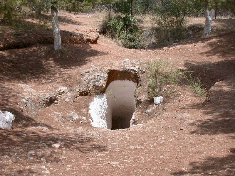
The Small Doline, called Μικρη Σπηλια (Mikri Spilia, Small Cave) is reached from the Didyma bypass road on 500 meters of paved road. A small parking area is sufficient for the few tourists who get to this point. Actually it is intended for the locals who have festivals on certain days of the year at the cave church. The doline is located inside a patch of pines, which are much darker than the olive trees, so from some distance it’s not possible to see the doline, but it’s easy to find it looking for a patch of darker trees.
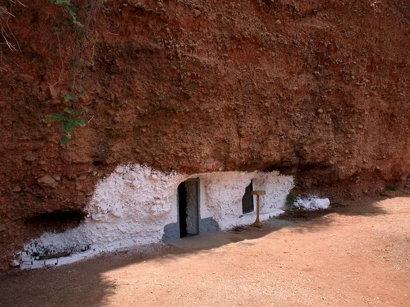
The first surprise is a group of some pines with a rectangular hole in the ground. A few years ago the hole was surrounded by an wrought iron fence with a gate, but as far as we know the gate is always open. As you approach, you can see a steep staircase leading down into the rock. This tunnel is rather narrow and a little low, only suitable for one adult at once, with a long staircase cut into the rock. The walls are painted white, a lamp is not necessary. The staircase goes down, turns twice and soon reaches the inside wall of the doline. From a terrace another staircase goes down onto a wide path which goes half around the doline, at the foot of the cliff along the wall. To the right is small church, and on the opposite side of the doline another one.
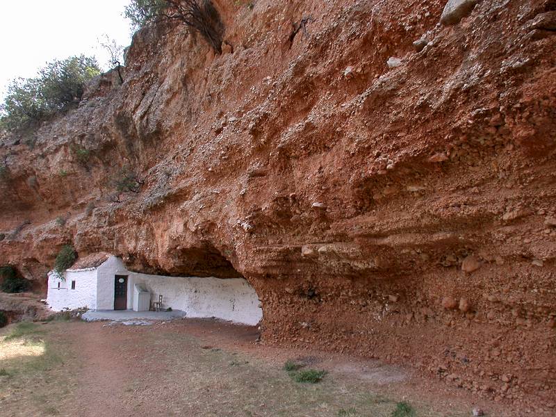
These two little churches were built under the overhanging cliff of the doline walls. The churches are of byzantine origin. The southern is called Σπηλαιώδης Εκκλησία του Αγίου Γεωργίου (Spilaiódis Ekklisía tou Agíou Georgíou, Cave Church of Agios Georgios). The northern is called Σπήλαιο Εκκλησία της Μεταμόρφωσης (Spílaio Ekklisía tis Metamórfosi, Cave Church of the Transfiguration). The churches may be the explanation for the "wrong" name, as they are called cave churches, being built under the overhanging cliff. So probably the caves are the shelters in the cliff, not the circular hole.
The southern church has no back wall and only part of the roof, the rear part is built into the overhanging cliff. It contains frescoes from the 15th century. For this reason the church is normally closed, to protect them from vandalism. The church is open only on festivals.
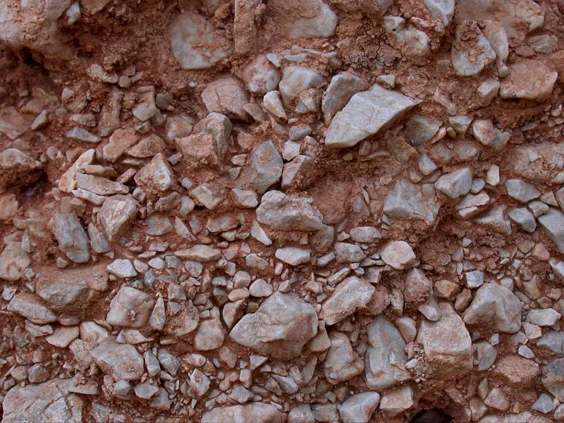
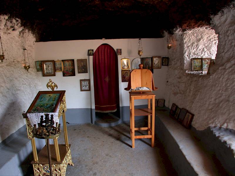
The northern church is a real cave church, as it has only a front wall, the rest is inside the cliff. It is not clear, if this small cave is of natural origin. Probably there was a small cavern, which was widened manually. This is pretty easy, as the walls of the doline do not consist of limestone. They consist of gravel, limestone debris with some red clay. It is not even breccia, as it is not lithified, it is sediment not sedimentary rock.
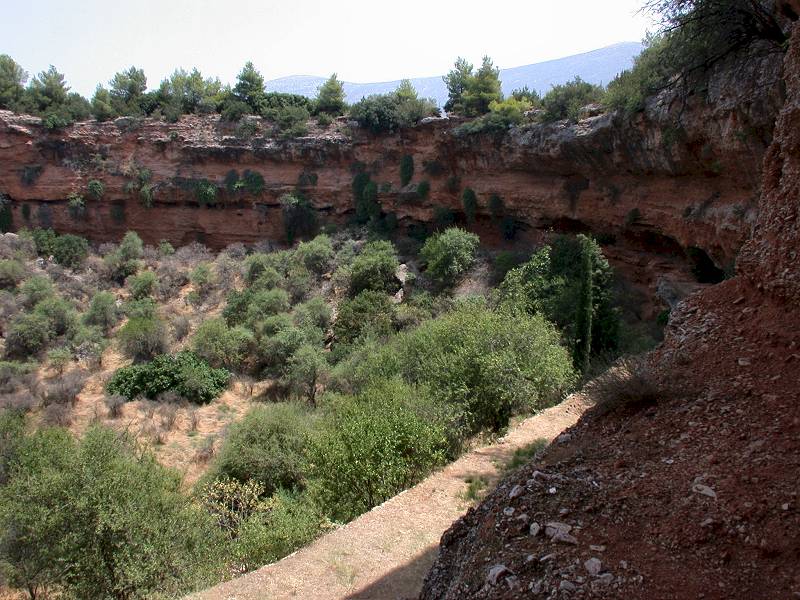
The geologic situation of this doline is a bit tricky. It is rather unlikely, that a huge cavern formed in the sediment. The formation of a cavern would be pretty easy, as the sediment is loose and does not resist to erosion very much. But such a sediment is not stable and would collapse pretty fast. The huge size of the doline, about 80 m in diameter and up to 30 m deep, requires a pretty big chamber, which caved in to form this doline.
A hint for the explanation is the geography. The big doline, lies on the slope of Mount Didymos (778 m asl), which consists of karstified limestone. At the foot of this mountain a rather flat valley ground starts, obviously filled with the limestone debris of Mount Didimo, the reddish gravel forming the walls of the small doline. Most likely there is a big cave system cave with huge chambers in the massive limestone below the debris. When the ceiling became too thin the limestone collapsed and the sediment above fell in and filled it. As a result a sort of pipe formed, where the ground went down. The chamber was probably a bit higher than the 30 m depth of the doline and so a circular pipe of sediment went down 40 m. During such processes a part of the space is afterwards distributed in rge sediment in form of small cracks. But still the drop was 30 m when it reached the surface. But as the layer of sediment is thicker than 30 m, so the walls still consist of the reddish gravel. It is unknown how deep below the massive limestone starts.
However, there are alternative explanations, how the doline was formed. The second most likely is the less spectacular one of a connection to the cave below, through which the material slowly fell down and was transported away through the cave. In this case there is no need of a huge chamber for the explanation. A cave river with enough water and force to move the small limestone pebbles is sufficient. As a result a depression forms above the connection to the cave and the doline forms by slow and rather continuous movement.
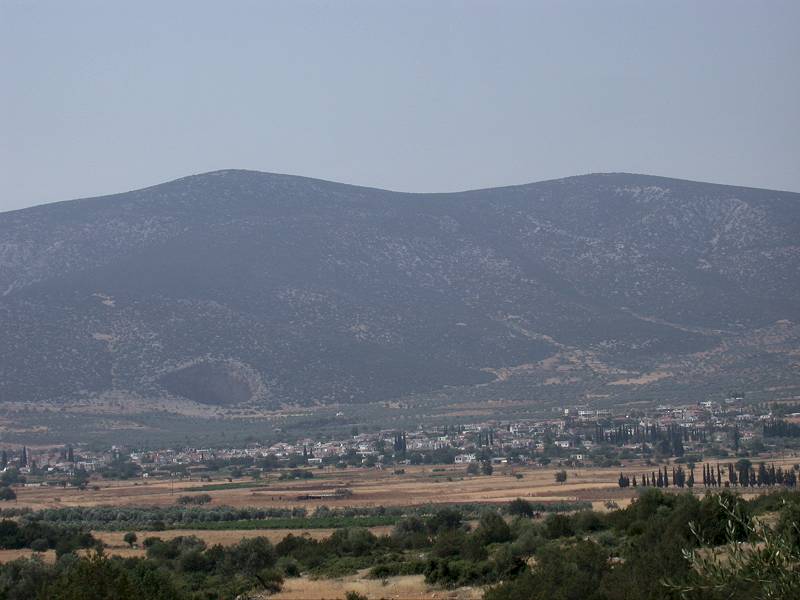
Whatever the exact origin of the dolines might be, there is a huge cave involved, which drains this region to the sea. The city of Didyma is located in a huge almost circular depression, surrounded by hills, which has a diameter between 3 and 3.5 km. The center at the eastern side of the town is about 150 m asl, the flat floor rises slowly to about 200 m around the dolines. This depression has no surface drainage, although there might once have been an outflow towards southeast, to the Salanti beach. This huge circular depression is obviously a polje and is drained by a cave system which is most likely also responsible for the dolines.
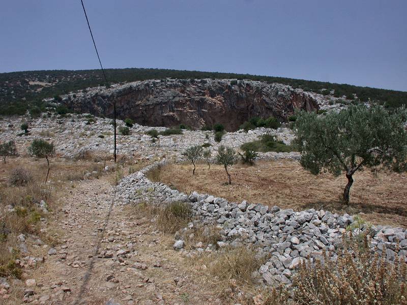
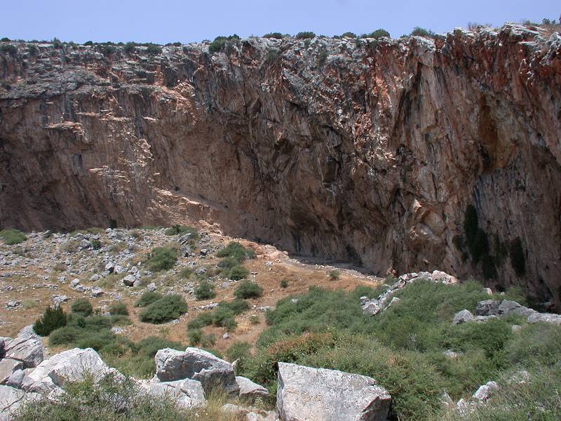
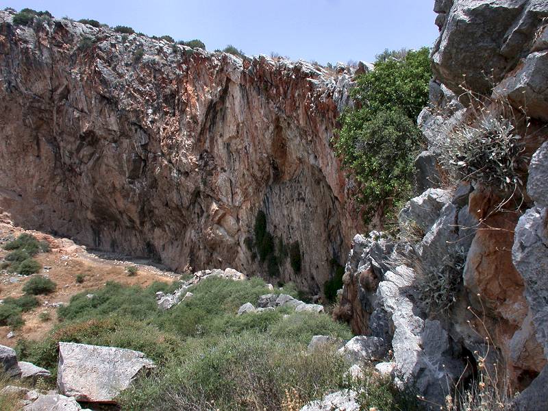
The Big Doline, called Μεγαλη Σπηλια (Megali Spilia, Big Cave) is 500 m up the road. As the paved road ends at the small doline, and the road becomes unsuitable to normal cars, a short walk of 10 minutes through olive trees is required. If you do this in summer take enough water with you and wear a hat. The path along a dry wall ascends a little, meandering trough olive trees, until the foot of Mount Didimo is reached. Now huge boulders of limestone form a sort of dam. Many small paths, the result of goats or sheep climbing through this rough terrain, allow a rather comfortable ascend onto this dam, where the whole doline is easily visible.
The collapse at this steep slope produced a quite asymmetric shape with two different sides. This southern side is rather low and the same paths continue down into the doline. The opposite wall is a pretty high and overhanging limestone cliff, about 90 m high at the highest point in the middle. The ground of the doline is full of debris and some shrubs grow between the rocks. The ground is obviously used to graze goats, the sheds were built at the foot of the slightly overhanging wall.
Archaeological remains believed to be Neanderthal and dated to 40.000 years BP, were discovered in the dolines. The small doline is also famous for yellow-red wild tulips that bloom here every spring. They were not able to grow them anywhere else, probably they need the special coolness and humidity of the doline. Every year in spring, the tulip festival takes place.
This site is definitely spectacular and one of the geological and speleological highlights of the Peloponnese. Unfortunately (or probably fortunately) it was never discovered by mass tourism. There is no infrastructure, no annoying shop owner trying to sell models of white houses with blue roofs. The most populated days are the few local festivals, when the locals use the site, attending mass at the churches. Recently some high quality drone videos were published on youTube, see the links below. They are recommended, as that’s the only way to give a realistic impression of the site.
The area has more speleological sights, but they are tricky to find. 3 km north of the two dolines are two more dolines almost on top of the hill, which are almost the same size. Those are not signposted, and it is necessary to walk some distance across the karst plateau to reach them. They are called Δολίνες Πελεής (Dolines of Peléis). The Ανατολική Πελέης Δολίνα (Eastern Peléis Doline) is 220 x 170 m, the floor is 500 m asl, the northern rim 530 to 540 m asl, the highest rim is at the eastern end and about 580 m asl. Like the Big Doline it is located at the slope, in this case the northwestern, and quite asymmetric. The Δυτική Πελέης Δολίνα (Western Peléis Doline) doline is 250 x 180 m, the floor is 434 m asl and the rim is between 450 m asl on the northern rim and 485 m asl on the southern.
If you want to reach them start at the highest point of the road from the north to Didyma, before it descends into the polje. Here is a large gravel parking lot on the eastern side of the road. You can either park your car or follow the gravel single lane road for 2 km. This road is in good shape, it was built for the construction of a wind park, and as far as we know there is no restriction to use it. However, from this point you have to walk, a trail leads north to the dolines. After 250 m you will reach a small and shallow doline, which has an exceptionally flat floor. 300 m further on you can go east to the eastern doline and west for the western. There are no trails into the dolines, but from here there are slopes with bushes to the floor which allow the descent.
- See also
 Search DuckDuckGo for "Didyma Cave"
 Google Earth Placemark: Small Didyma Doline
 OpenStreetMap
- Google Earth Placemark: Big Didyma Doline
- Google Earth Placemark: Eastern Peléis Doline
- Google Earth Placemark: Western Peléis Doline
 Didima (visited: 20-DEC-2022)
- Κρατήρες στην Ελλάδα | Craters in Greece Drone - youTube (visited: 20-DEC-2022)
- Didyma (Δίδυμα) Caves / Dolines (Σπηλαια Διδυμων) - youTube (visited: 20-DEC-2022)
- Σπήλαια Διδύμων και Μονή Αυγού
 (visited: 20-DEC-2022)
 Index
Index Topics
 Hierarchical
 Countries
 Maps
Maps