Peak District
The North Midlands

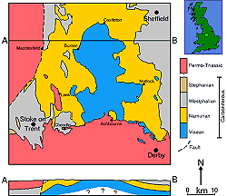
In the Peak District, a 450 km² outcrop of Carboniferous Limestone is the location of many interesting caves. The area is 40 km from north to south and 20 km from east to west. The Peak District is a National Park.
The limestone area ist a karst area with typical subterranean drainage. It is surrounded by areas with Triassic Sandstones and Namurian Millstone Grit, which support surface drainage, so there are numerous karst springs along the border of the limestone. Most of the show caves are located here, because the springs allow access to the caves.
 Lud’s Church
 Reynard’s Cave
 The Buxton Area
 Poole’s Cavern
 Odin Mine
 Search Duck Duck Go for "Peak District cave mine"
 PeakDistrict.org (visited: 19-JAN-2026)
 Index
Index Topics
 Hierarchical
 Countries
 Maps
Maps Search