Pirunpesä
Useful Information


| Location: |
Pirunpesäntie 100, 61730 Yli-Valli.
(62.3990652, 22.8954193) |
| Open: |
JUN to JUL daily 12-20. AUG Sat, Sun 10.18. [2024] |
| Fee: |
Adults EUR 6, Children EUR 3. [2024] |
| Classification: |
 Glacial Mill Glacial Mill
|
| Light: | n/a |
| Dimension: | Ø=14, VR=23 m, A=141 m asl. |
| Guided tours: | self guided |
| Photography: | allowed |
| Accessibility: | no |
| Bibliography: |
Heikki Hirvas, Seppo Lahti, Jouko Niemelä (1982):
Pirunpesä - preglasiaalinen rapaumaonkalo Jalasjärvellä
Geologi 34 (1982) : 4, pp. 61-64.
online

|
| Address: | Devil’s Nest (Jalasjärvi), Pirunpesäntie 100, 61730 Yli-Valli, Tel: +358-50-5445921. |
| As far as we know this information was accurate when it was published (see years in brackets), but may have changed since then. Please check rates and details directly with the companies in question if you need more recent info. |
|
History
| 1980 | geological examination. |
| 1997 | site opened to the public. |
Description


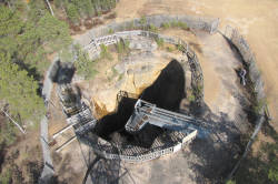
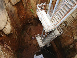
Pirunpesä (Devil’s Nest) is not actually a karst feature, it’s an erosional feature created by the glaciers of the ice age. But as it looks like a doline or daylight shaft, we decided to list it, and is it is not a cave, due to the lack of a roof, we added it to the karst features. The hole in the ground is 14 m in diameter, almost circular with vertical walls, and 23 m deep. However, this is "artificial", the pothole was originally filled with large boulders with cracks between them. Those cracks were believed to be the home of the devil, probably there were events with cold and humid air from the cracks forming fog. However, the locals were quite serious about this legend and warned their children to stay away, otherwise the devil might come and take them away into his nest. Another local legend was that if you dropped a small stone between the boulders, it would fall from stone to stone for several minutes. However, the name Pirunpesä is quite popular and there are dozens of other locations with this same name in Finland.
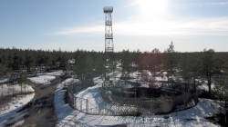
Today the hole is a tourist site, it has a railing, an outlook at the rim, a staircase which leads down to the bottom of the shaft, and finally an outlook tower. For 25 years it was operated as a tourist attraction by the Yylivalli youth club. It is also the starting point of two hiking trails, a short one which is 1 km long and a long one which is 7 km long.
Such circular holes with vertical walls in insoluble crystalline rocks are obviously a result of erosion.
They are not related to dolines, despite the similar shape.
They are generally called
 pothole.
In Switzerland, they are called glacier mills, which gives the first hint that it might be the result of melting water from glaciers milling around.
A massive river formed a vortex at this place, which transported sand and gravel in circles, at the same location for a rather long time.
The sand and gravel in the water caused abrasion, mechanical erosion of the rock surface, and as a result it "drilled a hole".
The vortex must have been of enormous size, about the size of the pothole, which is 14 m in diameter.
In other words, there was a massive river which flowed for a long time at this location.
It could be the result of melting water from the glacier, which flowed underneath the ice during the beginning of the warm phases.
The problem is, though: there is no river, no river sediments, and no valley.
Actually, the pothole is located on a shallow hill overlooking the swampy surroundings.
This could be explained with the next glacier moving this material away.
The Ice Age lasts now about 2.5 Million years, and there were numerous increases and decreases in temperature, at the beginning with a rhythm of 100,000 years, today it’s faster, and one circle lasts only 50,000 years. The last Cold Age ended 12,000 years ago, and the melting of a 3.5 km thick layer of ice produces massive rivers. During the cold age, the glaciers move slowly southwards taking anything with them, sand gravel, even blocks the size of houses. The ground is polished there are even marks from the scraping glaciers on the hard crystalline bedrock. But when the ice melts, the content of the glacier is deposited where it is and huge rivers of melting water form.
However, this is the general explanation to all other such holes we have listed in Finland. But in 1980, three geologists made a geological examination of the area. They visited the site, and while the hole was excavated by the municipality, they took probes and analyzed them. They interpreted the hole as the result of pre-glacial weathering, so its age is more than 2.5 Ma. The site was the result of tectonic stress, and the rock was eroded by frost weathering in the area of those cracks. It does not explain how a cylindrical part of the rock has so many cracks, circular and horizontal, but the rest of the rock does not have cracks. All the other erosional sediments surrounding the hole were removed by the glacier, that’s obvious. And the glacier was scraping over the hole in the ground, removing a few meters of the sediment on top. Those meters were filled with the material from the melting lacier in every warm age and removed again in the next cold age. Also, the southern edge of the hole was rounded by the glacier.
You should definitely also visit another nearby attraction, only 100 m away. It is the Kollinluola (Cave of the Tomcat), which is a neotectonic cave. According to legend, Juho Korkiakoski lived here as a hermit in the 1840s. He was tired of living in the city, became a dropout and lived in this small cave supporting himself by hunting and picking berries. The legend also tells the cave was named after him, he was nicknamed Kolli, and the name of the cave is actually Kolliluola. We were not able to find out who he actually was, probably a local celebrity. We guess he was the Finnish Henry David Thoreau, who lacked the literary background.
- See also
 Search DuckDuckGo for "Pirunpesä"
 Google Earth Placemark
 OpenStreetMap
 The Devil’s Nest - Wikipedia (visited: 25-OCT-2024)
 Retkeilyä, nähtävää, matkailua
  (visited: 25-OCT-2024)
 Kollinluola
  (visited: 25-OCT-2024)
 Kollinluola - cave of the tomcat (visited: 25-OCT-2024)
 3D (visited: 25-OCT-2024)
 Index
Index Topics
 Hierarchical
 Countries
 Maps
Maps