Creugenat
Creugenat Estavelle - Creux-Genat
Useful Information
| Location: |
2906 Haute-Ajoie.
Motorway 16 exit 4 Porrentruy-Ouest, towards Porrentruy, at the roundabout with the dinosaur turn left towards Fahy/Damvant/Courtedoux. When the road crosses the Transjurane A16 Viaducs du Creugenat Courtedoux, the estavelle is across the fields on the other side of the valley. Shortest walk: in Courtedoux at roundabout turn left, no signs. 100 m after the last house turn right, signposted bicyles to Réclère/Chevenez. Follow the paved single-lane road to the no entry sign, park along the road, follow road ahead, at the right turn follow the border of the forest on the field straight ahead. 600 m walk. (47.3963628, 7.0273790) |
| Open: |
no restrictions. [2024] |
| Fee: |
free. [2024] |
| Classification: |
 Estavelle Estavelle
|
| Light: | n/a |
| Dimension: | Cave: A=451 m asl, L=2,125 m, VR=20 m. |
| Guided tours: | n/a |
| Photography: | allowed. |
| Accessibility: | |
| Bibliography: |
Marc Hessenauer, Pierre Xavier Meury (2002):
Estavelle from Creugenat, Jura,
Stalactite N° 2 December 2002.
Jonathan Vouillamoz (2013): Mapping Flood-related Hazards in Karst Using the KARSYS Approach: Application to the Beuchire-Creugenat Karst System (Ju, Switzerland), 13th Sinkhole Conference NCKRI Symposium 2. online online DOI |
| Address: | |
| As far as we know this information was accurate when it was published (see years in brackets), but may have changed since then. Please check rates and details directly with the companies in question if you need more recent info. |
|
History
| 1933 | first speleologic exploration. |
| 1934 | first diving attempt by Spengler and Scherrer. |
| 1973 | exploration by Gérard Domon and the Groupe Spéléo de Porrentruy (GSP). |
| 2000 | spring pumped and cave explored by Club Spéléo de Porrentruy. |
Description
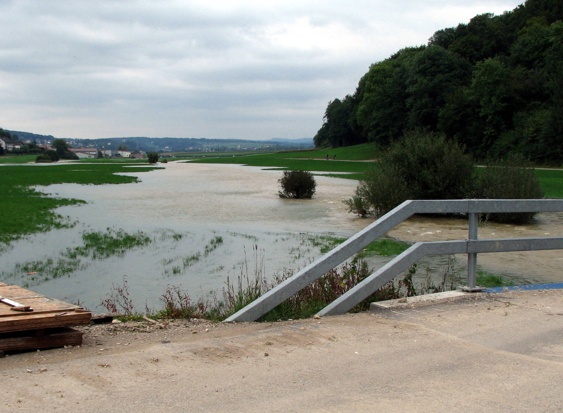
The Creux-Genat or Creugenat (Witches Hole) is a karst spring located at the border to France in the Swiss Jura. The translation as witches’ hollow ("Creû dè Djenâtches") is common knowledge, but actually recent research in the archives makes it more likely that the name derives from the patois "creûjenat", which means small hollow, or from the verb "creûjenaie", to dig. However, despite looking like a karst spring it is actually an estavelle, which means there are times when water flows out, times when water flows in, and even times when nothing happens. As an intermittent spring it is dry most of the year, but about four to five times every year after heavy rains or during snow melt the spring has a yield of typically 20 m³/s. At this time it is comparable to a spring of Vaucluse type. There are years with 10 or more such floods, but also years without (e.g. 2011). The water flows across the Courtedoux plain and finally into the La Beuchire spring in Porrentruy and then meets the Allaine river. There is no real riverbed, at some points there is a shallow grassy ditch, at others it’s just a field, probably leveled by a farmer. The water flows across the fields and floods a large area. The Courtedoux plain is quite flat, and the outflow often forms a temporary lake. When the flow ends, the karst groundwater level may fall faster than the level of the temporary lake and so the water flows back into the cave. This is what the term estavelle means.
When the spring is dry, the water cave below can be visited by cave divers, and it has been explored for 2,125 m by now. Many parts are water filled, but there are also some air-filled passages behind the entrance sump. Several attempts were accompanied by pumping the entrance sump, because this makes the diving much easier. One of the first explorations by cave divers was in winter 1933/34 by the divers of the Losinger company Spengler and Scherrer from Zürich. They widened the passage right below the surface and were able to explore about 60 m. The main problem was dragging the air hoses behind them. But in summer 1934 they were lucky, the summer was very dry, and all the springs in the area fell dry, and they could explore them without diving equipment. Then there was a large pause until Gérard Domon, president of the Porrentruy Speleo Group (GSP), resumed explorations in 1973. He teamed up with Cyrille Brandt from the Groupe lémanique de plongee souterraine and André Pahud of the Société spéléologique de Genève. They explored and surveyed more than 2 km of passages. The Club Spéléo de Porrentruy pumped the sump in 2000 and researched the entrance area. This phase of exploration ended in 2003, and since then no new attempt has been made. But a group of divers led by Émilien Boisson and Christophe Meyer resurveyed the already known part with higher accuracy.
The catchment area of the Ajoulote underground river is the Doubs basin between Faltenjura (folded Jura) and Milandrine basin. It has a size of 48 km². The main drainage is through the La Beuchire spring in Porrentruy, the most important karst spring in Ajoie with flow rates between 60-80 l/s and 2,900 l/s, in average 800 l/s. The Creugenat estavelle is 4.25 km away and is a higher overflow, so it is activated only when the water level in the karst body raises high enough, because the main spring is not able to drain it fast enough. Normally, it starts flowing when the outflow at Beuchire reaches 1,450 l/s.
 Search DuckDuckGo for "Creugenat"
 Google Earth Placemark
 OpenStreetMap
 Creugenat - Wikipedia
  (visited: 16-MAY-2020)
 Estavelle from Creugenat, Jura (visited: 24-MAY-2020)
 Index
Index Topics
 Hierarchical
 Countries
 Maps
Maps