Geology of Cook Islands
©George Szentes, with kind permission.
Holiday makers, tourists and scuba divers do not realise that there is much for the speleologist to search for in the Cook Islands. But that is the case.
The Cook Islands have a total land area 241 km², however this land is scattered over 2 million sq km of sea, an area as large as Western Europe. The Cooks are south of the equator, just east of the International Date Line. The 15 islands are divided into a northern and a southern group, separated by 1000 km of empty sea. The northern island group are older, low lying, coral atolls. The northern islands have no significance regarding karstification or caves.
© George Szentes, with kind permission.
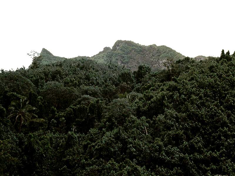
The southern islands are generally larger, constituting about 90% of the total area. They are the continuation of the Austral Islands, lying along the same north-east south-west fracture of the earth’s crust. The largest island, Rarotonga (67.2 km²), is basically a mountainous, volcanic island up to 650m asl. Aitutaki Island has one small hill around the atoll reef. It is known as "almost atoll".
Four of the Southern Group of islands, the so called "raised islands" have a remarkable topography showing signs of karstification and cave development. These islands are: Atiu, Mauke, Mitiaro and Mangaia. The islands are located about 200-250 km from the main island. They were formed about 10 million years ago in the distant geological past, as volcanic islands and gradually became encircled by coral reefs. Over time the volcanic cones sank and the Pacific plate moved on. Two million years ago more volcanic activity occurred. This time the main island, Rarotonga, appeared. The same activity caused a buckling of the sea floor in the area nearby, causing the four islands to be raised above sea level. This exposed the coral reefs, which became fossilized coral limestone, forming the rugged coastline and the low lying plateaus. In the last 100,000 years a narrow belt of young coral reefs developed around most of the islands. In the central part of the islands are depressions in the middle of the limestone plateaus. Here can be found the remains of the volcanic rocks, which are covered by fertile soil. These depressions are very important for the supply of fresh water. Between the depressions and the limestone plateaus, swampy rims were formed. The islands can be described as being like a very low brimmed hat with a flat outer rim.

© George Szentes, with kind permission.
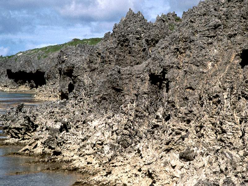
The fossilised coral limestone has undergone intense karstification. The climate is humid and hot. The yearly rainfall is about 3,000-4,000mm. From December to March 2,500mm rain is expected and the average temperature at this time of year is around 29 °C. The vegetation on the limestone plateaus is thick, low growing, tropical scrub jungle. As a result of the tropical limestone solution and the characteristics of the coral limestone, very rugged surfaces have developed. This is the so called "makatea". The makatea covering the plateau surfaces hides a razor sharp 1-3 m high mass of limestone rocks. Between these are deep, vegetation covered fissures. This makes it extremely difficult to gain access to the caves. The most important piece of equipment is a thick walking stick, which serves to find the dangerous fissures.
The limestone plateaus resemble a sponge as a consequence of the combined solutional effects of the infilitrating rain water and the tropical vegetation. This is the basis for cave development. In the islands several hundred minor caves and cavities exist. In some favourable cases extensive caves with large chambers have formed. Due to the frequent changes to the sea level in the last 15,000 years, some of the caves are now beneath the water table.
Text from George Szentes (2004): Caves of the Cook Islands, The British Caver Vol. 127 Spring 2005, pp 1-12, 13 color pictures, 1 bw picture, 1 map. With kind permission of the author.
 Search DuckDuckGo for "Cook Islands Geology"
 19. Geological History of the Cook Islands (visited: 02-JUL-2018)
 Index
Index Topics
 Hierarchical
 Countries
 Maps
Maps