Mitchelstown Cave
Useful Information
| Location: |
Burncourt, Cahir, County Tipperary.
Mitchelstown lies half-way between Cork and Cashel on the M8. M8 exit 12 Mitchelstown, R639 towards Kilbeheny. M8 exit 11 Cahir, R639 towards Kilbeheny. Turn off towards Bunrcourt, follow the signs. 13 km from Mitchelstown, 15 km from Cahir. (52.3039301, -8.1085682) |
| Open: |
All year daily 10:30-16. Booking mandatory. [2024] |
| Fee: |
Adults EUR 11, Children (0-14) EUR 5, Family (2+2) EUR 26. [2024] |
| Classification: |
 Karst cave Karst cave
|
| Light: |
 Incandescent Electric Light System Incandescent Electric Light System
|
| Dimension: | L=2,500 m, T=12 °C. |
| Guided tours: | L=1,000 m, D=30 min, Min=2, St=88. |
| Photography: |
No way, definitely not.
 Why taking pictures is forbidden... Why taking pictures is forbidden...
|
| Accessibility: | no |
| Bibliography: |
James Apjohn (1834)
On the Mitchelstown Cave
Journal of the Geological Society of Dublin.
Dr. James Apjohn (1834). On the Mitchelstown Cave Dublin Penny Journal. 3: 203–208. É.-A. Martel (1896): Mitchelstown Cave Irish Naturalist. 5 (4) April 1896. Dublin: Eason & Son: 101–105, Plate 2. archve.org Arthur Wynne Foot (1878): An account of a visit to the cave of Dunmore, Co. Kilkenny, with some remarks on human remains found therein Journal of the Royal Society of Antiquaries of Ireland. 4. I. Dublin: 67. online Ernest A. Baker, Herbert E. Balch (1907): The Netherworld of Mendip, J. Baker & Son, London 1907. gutenberg D. J. Gargan (1939): The Desmond cave at Mitchelstown At the sign of the three candles, Fleet Street, Dublin, 1939. pdf |
| Address: |
Mitchelstown Cave, Burncourt, Cahir, County Tipperary, E21 H920, Tel. +353-52-7467246.
E-mail: |
|
As far as we are aware, this information was correct at the time of publication (see year in square brackets), but may have changed since then. Please enquire directly with the companies concerned for prices and details if you require more up-to-date information. |
|
History
| 1601 | the Earl of Desmond took refuge in the old cave. |
| 03-MAY-1833 | New Cave discovered by Michael Condon. |
| 1834 | first survey by Dr. James Apjohn, Professor of Geology at Trinity College Dublin |
| 1857 | explored by the famous botanist A. H. Haliday. |
| 1895 | visited by
 E. A. Martel. E. A. Martel.
|
| AUG-1905 | visited by E. A. Baker and Dr. C. A. Hill. |
| 1908 | resurveyed by members of the Yorkshire Ramblers Caving Club and Ireland’s most famous naturalist R. L. Praeger. |
| 1972 | major development works, electric light. |
| 1983 | celebration of 150-year discovery of the cave. |
Description
(© Mathias J. Duckeck)
(© Mathias J. Duckeck)
Mitchelstown Cave was discovered in 1833 by the local farmer Michael Condon. He lost his crowbar in a crack while breaking stones for his house. Trying to find his tool and digging along the crack, he opened a cave. This entrance is used until today. This cave was first called the New Cave, as another cave nearby was known for many years, which was then called the Old Cave. This old cave is today called Desmond Cave, or Old Desmond Cave, which seems to be a combination of the two names. According to local lore, it was used as a hideout by the Súgán Earl, James FitzThomas FitzGerald.
The title Earl of Desmond was held by 14, 15, or 16 people, which is quite complicated, and explained in detail on Wikipedia. The 14th (last) Earl of Desmond was catholic and refused to switch to protestantism, and as a result started the Desmond Rebellions in 1583. He failed and was killed by forces loyal to Queen Elizabeth I on 11-NOV-1583. The title, along with the enormous estates of his family, were forfeit to the English Crown. James FitzThomas FitzGerald actually never held the title, he attempted, to regain the title during the Nine Years War, but failed. But after he had failed he joined the rebellion in 1598 and assumed the title of Earl of Desmond, leading eight thousand clansmen. The Irish word Súgán means literally straw, but here it means pretender. During this rebellion he used the cave several times as a hideout. But finally in 1601 he was captured, and is believed to have died in 1608 in the Tower of London. Desmond Cave is not open to the public, as a visit is highly dangerous because of a 6 m deep entrance pit. The cave was despite the pit used by the locals as a refuge during the troubled times of 1798 and 1918. During the famine years, the stalagmite formations were ‘mined’.
Michael Condon explored the cave after his discovery accompanied by two boys with the surname Shelly. All three were no cavers, their only equipment was candles and matches, and a rope. They used a burning turf tied to a string to judge depths of shafts. But they underestimated the size of the cave, and turned around too late, the last candle burned out leaving them in complete darkness. They were unable to leave the cave on their own in the darkness, but after 12 hours the father of the two boys found them.
When the cave was discovered, the area of Mitchelstown Cave was owned by the English Earls of Kingston. The Mulcahy family lived on the farm around the cave entrance. When the 40,000 ha estate went bankrupt, the farmer, who was tennant, bought the land of his farm including the cave. These events happened around 1850, as a result of the Great Famine, the high costs for the construction of Mitchelstown Castle in combination with the finacial problems caused by the famine, forced the Earl to sell 70 % of his land.
News spread fast and soon curious sightseers came to visit the cave. To reduce the danger for the visitors and the cave, the Mulcahy family, which lived in the farmhouse in front of the cave, acted as guides. During the 19th century, several famous scientists explored the cave. A. H. Haliday gained fame in 1837 when he received insects, collected by Charles Darwin on HMS Beagle. The Darwin Insects are now exhibited in the National Museum of Ireland. Twenty years later, in 1857 he explored the Mitchelstown Cave. Later it was explored and survey by the cavers of the Yorkshire Ramblers' Club Between the 1930s and the 1970s, the Cork Speleological Group and the University College Cork explored the cave. With so many visitors, the cave was actually a show cave from the beginning, but with minimal development. And the Mulcahy family were caretakers for generations. Today the farm is owned by the English family, who also operate the cave for generations. We are not aware how the name change happened, if the farm was sold or the name simply changed by marriage. In the mid 1960s, the owners decided to develop it and built trails and electric light. As a result, the cave was opened to the public in 1972 as the first show cave of Ireland.
The entrance was a cleft or shaft, originally the visitors had to climb down a rope ladder, later a fixed ladder. When the cave was developed, a stone staircase was built, with a sort of cellar door closing the cave. The entrance looks quite unimpressive from outside, like a harmless ceellar entrance. But the staircase has 88 steps until the niveau of the cave is finally reached. The largest chamber of Mitchelstown Cave is called Tir Na Nog and measures 61 m × 49 m and is 18 m high. In recent years it was used for concerts, showing movies, and even spectacular dinner events. The official Irish launch of the Samsung Galaxy S23 took place in Mitchelstown Cave and it was used as a filming location for movies and TV series. For example, the series Vikings, season 5, episode 19 "What happens in the cave" was filmed here. The hugest column, called Tower of Babel, stands about 9 m high.
The Legend of Mitchelstown Cave
There is a cave lake in the cave, which is not part of the guided tour.
According to local lore, whoever crosses the lake will never return.
Once a piper crossed the lake, and he became so engrossed in his music and the natural acoustics of the cave that he got lost in the maze of passageways.
To this day some visitors still hear music coming from distant sections of the cave.
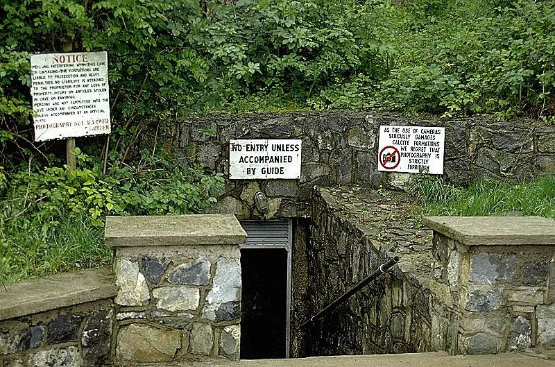
At Mitchelstown Cave photography is not allowed! This is nothing special, but the explanation is rather funny, as a sign, shown on the photograph to the right, reads:
As the use of cameras seriously damages calcite formations we regret that photography is strictly prohibited.
That is the reason why there are no pictures of the cave on this page!
We didn't want to be responsible for the destruction of the calcite formations.
The new owner told us some years ago, he removed the above sign, so this image is a historic document now.
But get it right: it is still forbidden to take pictures, there are just no funny signs any more.
He sent us some comments about this topic which made us believe, before he read our page, he actually believed in his own strange explanation.
When he read our comment, he asked someone he trusted, who affirmed our explanation.
But the guides still tell the legend that photography harms formations.
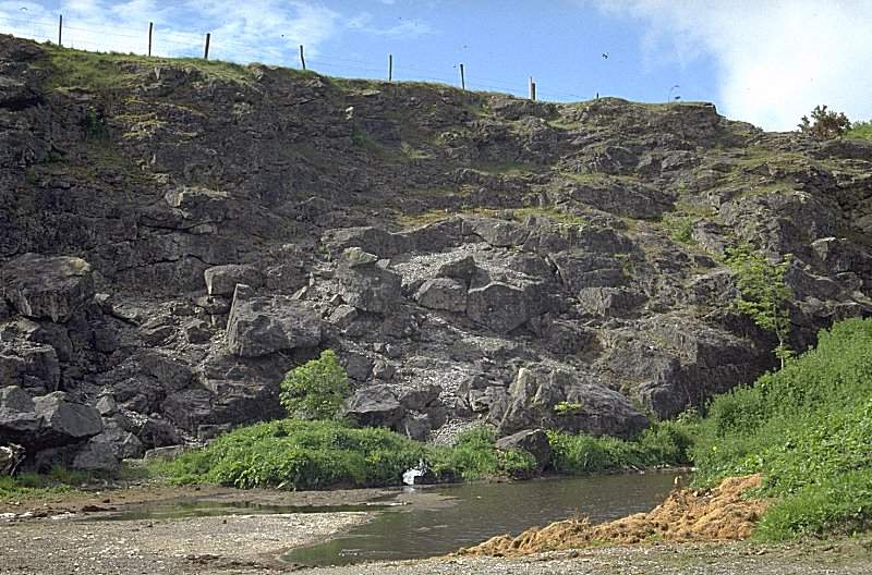
The karst around Mitchelstown is restricted to a rather small area. The Galtee Mountains and the Knockmealdown Mountains consist of sandstone, which contains no caves as it is not soluble by water. But between the two mountain ridges are two hills, which are the outcrop of a narrow strip of Carboniferous limestone. This is the location of the caves, and it is a material which is quarried for building stone and lime. Mitchelstown Cave is the only cave in this area open to the public.
- See also
- Why taking pictures is forbidden...
- Official Website Replaced by Facebook Page
 Search Google for "Mitchelstown Caves"
 Google Earth Placemark
 OpenStreetMap
 Mitchelstown Cave - Wikipedia (visited: 05-APR-2024)
 Mitchelstown Cave, official website (visited: 04-APR-2024)
- "Mitchelstown Caves" (visited: 04-APR-2024)
 Index
Index Topics
 Hierarchical
 Countries
 Maps
Maps Search