Smoo Cave
Useful Information
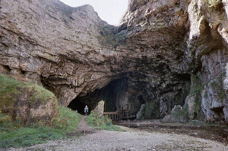
© Tony Oldham, with kind permission.

© Copyright 1994-2002 by
 Martin Junius. With kind permission.
| Location: |
Durness, North Scottish Highland Region.
2 km East of Durness on A838 to Lerinmore, at the head of a sea inlet.
OS sheet 9 419679, grid ref. NC 419.672. (58.564364, -4.719700) |
| Open: |
no restrictions. [2020] |
| Fee: |
free. [2020] |
| Classification: |
 Karst cave
sea cave
Blowhole Karst cave
sea cave
Blowhole
|
| Light: |
 Incandescent Electric Light System Incandescent Electric Light System
|
| Dimension: | L=83 m, H=18 m. Portal: H=16 m, W=33 m. |
| Guided tours: | self guided, L=100 m, D=20 min. V=40,000/a [2020] |
| Photography: | allowed |
| Accessibility: | no |
| Bibliography: |
Tony Pollard (1992):
Smoo Cave,
20 pp maps, figs. Archaeological excavation of Smoo Cave, Sutherland for Caithness and Sutherland Enterprise carried out by Glasgow University Archaeological Research Division. The cutting back and recording of an eroding shell midden section in Smoo Cave, Sutherland, resulted in the identification of several occupation / activity horizons. The shell midden, the earliest phases of what appeared to be Iron Age, represented the latest phase of Iron activity. The earlier deposits, which are substantially lower than the cave floor, may represent Mesolithic activity within the cave. The investigation also brought to light a further midden deposit located in a former cave some 50 m to the NW of Smoo Cave. |
| Address: | |
| As far as we know this information was accurate when it was published (see years in brackets), but may have changed since then. Please check rates and details directly with the companies in question if you need more recent info. |
|
History
| 19-AUG-1814 | visited by Sir Walter Scott. |
| 1904 | first organised excavation took place but a report was never published. |
| 1986 | cave was modernised, the footpaths improved and light installed. |
| 1992 | archaeological excavation in the cave. |
| 2002 | visited by Tony Oldham. |
Description


©Copyright 1994-2002 by
Martin Junius. With kind permission.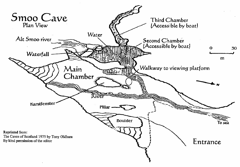
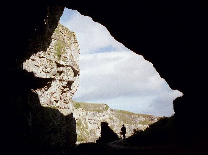
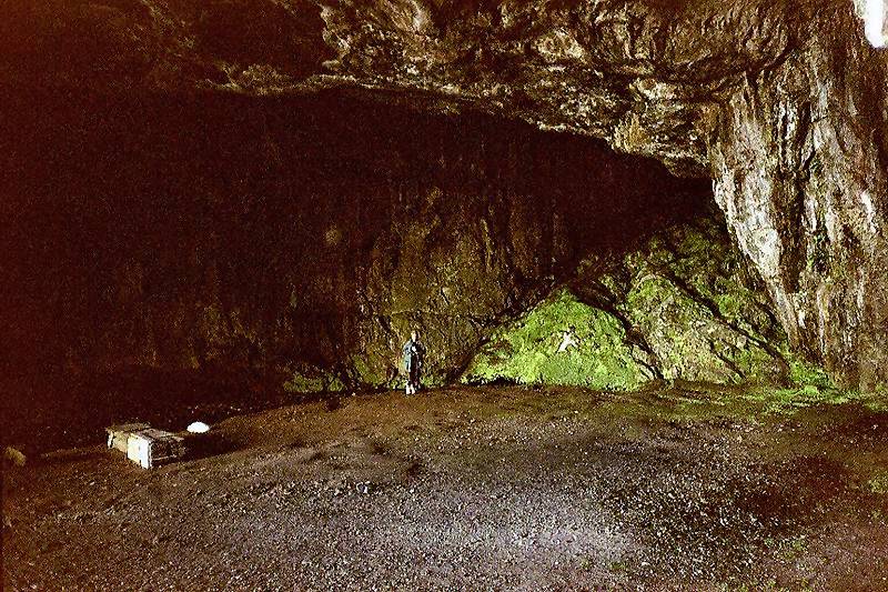
Smoo Cave is Scotlands only show cave. It is a rather large sea cave, but the rear part is a karst cave which formed inside limestones of the Durness Group. The cave is developed with wooden trails and has electric light, but there are no guided tours and no entrance fee. Only during summer holidays, when most of the 40,000 yearly visitors visit the cave, optional guided tours and boat rides into the second chamber are offered. Trails from the parking lot at the A838 are leading down on both sides into the Geodha Smoo, a 500 m long fjord-like cove in front of the cave. Right in front of the cave portal is a wooden bridge which crosses the Allt Smoo, the cave river. The trail goes into the cave along the river, then a covered wooden walkway leads to the second room with the huge opening where the Allt Smoo enters the cave from the surface above. It forms a waterfall and a pool or cave lake at the floor.
The first chamber has an opening to the surface, a karst fenster, which is named blowhole. It may actually create a blow hole, if during a heavy storm and high tide the water rises and fills the cave. Sea water is then forcefully pressed out of the opening with every huge wave.
The name Smoo Cave is thought to originate from the Norse 'smjugg' or 'smuga' which translates hole or hiding-place. The place was used by man since prehistoric times, human remains, remains of walls and several kitchen midden or shell heaps were excavated. If the name actually derives from the Norse, it must have been visited by the vikings, probably as a safe harbour and place to collect sweet water. However, no remains were found from this era. Then there are legends that it was used as a hideout by smugglers. Another legend tells that in the 16th century the highway man McMurdo murdered his victims by throwing them into the blowhole. And another legend concerning the Wizard of Reay is told by Tony Oldham, please follow the link below.
Visits since the 19th century are better documented, and there were numerous. The best description is from Sir Walter Scott who visited the cave in 1814. His diaries were published by J. G. Lockhart in 1880. The cave was finally explored by speleologists in the 1960s. They even discovered a small water filled passage behind the second chamber, which some call the third chamber.
The karst features of Smoo cave are typical for such a small limestone area with impermeable and insoluble rocks surrounding it. Brooks flowing on impermeable rock, disappear into swallow holes as soon as they reach the border to the limestone. This is called contact karst, which means intensified karstification at the contact between karst and not karst. The swampy areas of Scotland are full of the well known brown, peaty water. The humic acids in the water cause an extraordinary fast and intensive karstification. Such a cave river is Allt Smoo, which flows into a sink at the parking lot, reappears inside Smoo cave, and flows through the cave into the sea. It is quite obvious that Geodha Smoo is the result of this contact karst in combination with the erosion by waves and tides. The limestone was dissolved by the acid rich water while the insoluble rocks on both sides remained. And the future is also obvious: Geodha Smoo will grow deeper and deeper into the land, following the band of limestones.
The Durness Group are layers of limestones and dolomites. The rocks were formed during Ordovician and Lower Cambrian as shelf sediments. They are found in a narrow belt running north to south, from the area of the Smoo Cave to Ardarroch at Loch Kishorn. There is even a short belt of limestone in the same direction crossing the island of Skye near Broadford. The eastern border of this band is the Moine thrust, a famous and important system of thrusting and low grade metamorphism. The limestone belt is generally one or two kilometers wide. This narrow band of limestone is of great economic value, in an area where limestone is rather rare. Most quarries can be found near Ullapool and at Torrin, on Skye. And the whole belt is karstified, with numerous caves. The most important part of the belt is the Assynt area, about 40 km south of Smoo cave, where the belt widens and is nearly 10 km wide.
- See also
 Caves With The Tallest Cave Entrance
 Memoirs of the Life of Sir Walter Scott by J. G. Lockhart (1880).
- Smoo Cave, text from: Tony and Anne Oldham (1972):Discovering Caves - A guide to the Show Caves of Britain.
- Smoo Cave by Tony Oldham (2002). Extensive description with a survey.
- Smoo Cave Bibliography by Tony Oldham (2002)
 Search Google for "Smoo Cave"
 Google Earth Placemark
 Smoo Cave - Wikipedia (visited: 20-JUN-2020)
- Smoo Cave Tours (visited: 20-JUN-2020)
- Smoo Cave (visited: 18-NOV-2022)
- Smoo Cave, prehistoric occupation site (visited: 20-JUN-2020)
 Index
Index Topics
 Hierarchical
 Countries
 Maps
Maps Search