Wasserbaum von Ockensen
Water Tree of Ockensen

Useful Information
| Location: | At Ockensen. A7 exit Hildesheim, B1 34 km through Elze to Salzhemmendorf-Hemmendorf, then South 13 km through Salzhemmendorf towards Wallensen, immediately before Wallensen trun right to Ockensen, follow the signg through the village Ockensen. (52.022975, 9.592877) |
| Open: |
no restrictions. [2020] |
| Fee: |
free. [2020] |
| Classification: |
 Tufa Deposits
pillar of tufa Tufa Deposits
pillar of tufa
|
| Light: | n/a |
| Dimension: | H=3 m, D=1 m. |
| Guided tours: | n/a |
| Photography: | allowed |
| Accessibility: | yes |
| Bibliography: |
Franz Binot (nY):
Wasserbaum von Ockensen,
Institut für geowissenschaftliche Gemeinaufgaben.
pdf
E. A. Friedrich (1982): Der Wasserbaum von Ockensen, in: Gestaltete Naturdenkmale Niedersachsens, Landbuchverlag, Hannover. |
| Address: | |
| As far as we know this information was accurate when it was published (see years in brackets), but may have changed since then. Please check rates and details directly with the companies in question if you need more recent info. |
|
History
| 1904 | Hermann Meyer opens his sawmill with a timber business. |
| 1926 | Sawmill is closed, sawmill and Wasserbaum is sold to the forest administration, Wasserbaum remains unattended. |
| 2004 | for the 100th anniversary seating group, fence and signage set up. |
Description
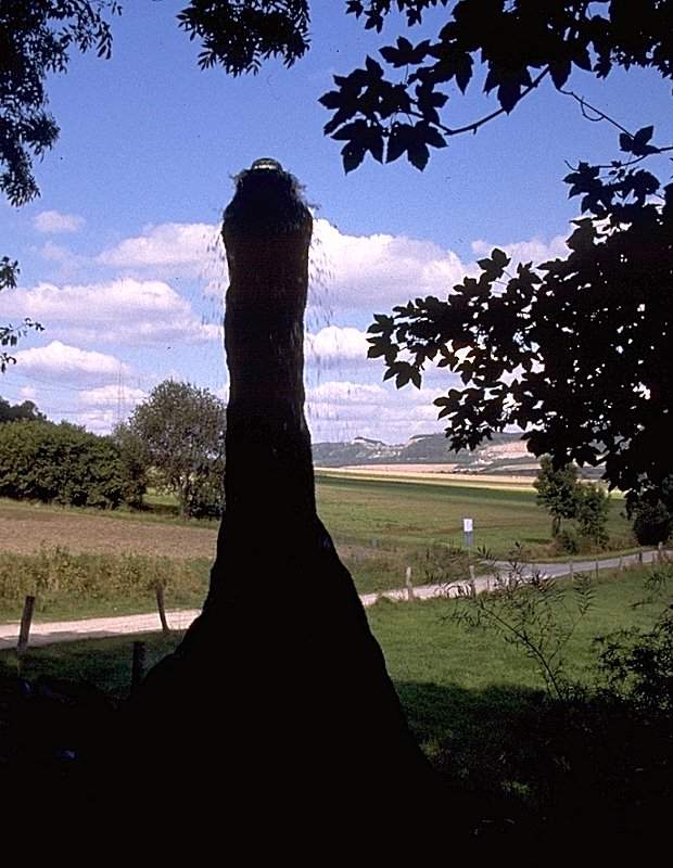
The Wasserbaum (water tree) is a unique curiosity. However, it is not a natural phenomenon, but an industrial monument in the broadest sense.
Since 1904 the saw miller Hermann Meyer operated a sawmill and wood shop in Ockensen. The saws were already running electrically, but there was still no electric grid at the town. The necessary electricity was produced from water power with a generator. He collected the water from a small karst spring called Ithhangquelle in a dam pond and used it to drive a turbine with a power generator. For the turbine to run evenly there had to be enough water in the reservoir. Unfortunately, the yield of karst springs changes, so it was necessary to checked daily if the water level was high enough. To do this, Hermann Meyer had to walk several hundred Meters up the slope to look over the dam and into the reservoir.
To solve this Hermann Meyer built a simple pipe with a square cross-section from four boards, which served as an indicator for the water level. According to the principle of communicating vessels, the water level in the tube is identical to the water level in the pond. If the water level in the pond is higher than the upper edge of the pipe, water will run over the upper edge. The owner could see this from below with binoculars, and knew when the pond was full enough without having to walk uphill to the lake.
The constant trickling of the calcareous water from the pipe has created a thick crust of calcareous tufa during its existence. The water loses carbon dioxide and the dissolved lime is precipitated. This process also leads to the natural deposition of calcareous tufa at karst springs. Due to the special shape of the wooden tube, the lime deposit has also taken on an unusual form, The term "water tree" is derived from the tree trunk like shape, and is at the same time an indication that the residents have obviously forgotten the technical background after only a few decades.
The sawmill went bankrupt in 1926 and was sold to the forestry administration together with residential buildings, ponds and water tree. The latter did not continue to operate the generator and from then on the water tree was constantly overflowed by water, which increased the formation of the limestone tufa. In the 1960s signs for the water tree were put up. However, it became somewhat better known with the publication of E. A. Friedrich in 1982, who used the extensive research of the local district forester Seyfarth. At this time the spring ponds were already marshy and had developed an extraordinary marshy spring biotope, which was placed under nature protection together with the water tree. It is also recommended to visit the ponds and the spring which is 100 m uphill. However, please stay on the paths. The Wasserbaum got its current appearance on the occasion of its 100th anniversary in 2004. To protect the geotope, a wooden fence was erected, but also paths, a seating green, and an explanatory sign.
 Search Google for "Wasserbaum Ockensen"
 Google Earth Placemark
 Wasserbaum Ockensen - Wikipedia (visited: 03-OCT-2014) (
 )
) Wasserbaum in Ockensen - Naturdenkmäler - Freizeit - Sehenswürdigkeiten - Regi-On (visited: 03-OCT-2014) (
 Index
Index Topics
 Hierarchical
 Countries
 Maps
Maps Search